Summary:
Press CTRL + P to print. Photos do not show when you print this page. (Help)
This hike begins at the Top Spur cutoff Trail #765. After a half mile climb
you intersect the Pacific Crest Trail #2000. Follow this trail for a couple hundred feet to the
right where you come to a major intersection of five (5) trail options. Select the trail
immediately to your left, Timberline Trail #600. Follow this trail for about another two
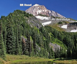
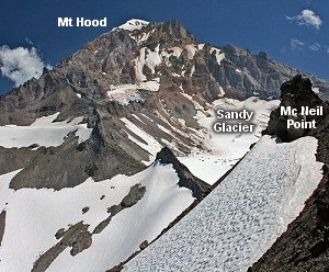
miles and you will come to a popular viewpoint of the Sandy Glacier on Mt Hood with the
Muddy Fork river valley below.
Continue up the ridge to a series of switchbacks that offer you on again off again views of
the surrounding hills and valleys. At about three and a half miles you will come to a small
basin with a couple of ponds. The upper pond on your left offers the best views of Mt Hood.
A short distance past this pond you will come to the intersection of the Mazama Trail.
Continue on about a quarter mile and the trail turns sharply to the left crossing a small
seasonal creek. At this point people used to leave the main trail and follow the user worn trail
more or less straight ahead. This trail then climbs sharply up a slope a bit to your left and
at the top of the ridge intersects the main trail to McNeil Point. But do not use this
route anymore. The area is becoming over used.
Instead stay on Trail #600 as you climb up over a small heavily forested ridge. In about a quarter mile,
the trail begins downhill for a short distance to a junction. Take the trail to the right
and follow it up the ridge toward Mt. Hood.
Follow this trail which in season is a floral paradise to the old shelter on McNeil Ridge.
An additional challenge awaits those who would like to climb up the very steep slope to
McNeil Point another 800+ feet above the shelter. Regardless, you will have already hiked through
some of the most beautiful natural surroundings that the Mt Hood area has to offer.
The following images are random samples of the wildflowers found in the Mount Hood National Forest.
Mouseover image to view flower name, and click on image to jump to flower guide.
Take the Lolo Pass Road (Road 18) out of Zig Zag
for about 4 miles. Bear right on Road 1825. In
about another mile, bear to the left and do NOT
cross the bridge over the Sandy River. Follow
Road 1828 about 6.5 miles to the junction with
Road 118. Bear right on Road 118 and follow it
another couple miles to the trailhead. Park head-in
on the opposite side of the road from the trail.
Vandalism is a problem here... so be aware.
Click on the link below to see a map taking you to the trailhead.