Hike 24 Top Spur to Bald Mountain Overlook Main Menu
Previous Hike Northern Hikes Mt Hood Hikes SE Central Hikes SW Central Hikes Southern Hikes Hike List Next Hike
MOVE MOUSE OVER MAP CAMERA ICONS () TO VIEW PHOTOS - F5 TO REFRESH
A PICTURE IS WORTH A THOUSAND WORDS


TRAIL POSITIONED PHOTOS OF THE HIKE
NOT TO BE USED FOR NAVIGATIONAL PURPOSES - ONLY FOR REFERENCE
Print Topo Map Hike Difficulty
Calculator
90° Pano
Legend Ten Essentials  

Hike Length: 3 miles round trip
Elev. Change: 300' gain
Hike Difficulty: Easy
Season: Summer thru Fall
Trail Condition: Good
Trail Access: Good
Trail Signage: Good
Features: Views, Wildflowers
Useage: Moderate
Permit: NW FP Required
Horses: No
Mtn Bikes: No

Summary:
Press CTRL + P to print. Photos do not show when you print this page. (Help)

Even though the first half mile of this trail is the same for the McNeil Point hike, I include this option as a viable choice for those with young children or the elderly.

This hike begins at the Top Spur cutoff Trail #765. After a half mile climb you intersect the Pacific Crest Trail #2000. Follow this trail for a couple hundred feet to the right where you come to a major intersection of four (4) trail options. Select the trail to the left of the wilderness sign in booth, which is Timberline Trail #600, the Muddy Fork trail. 
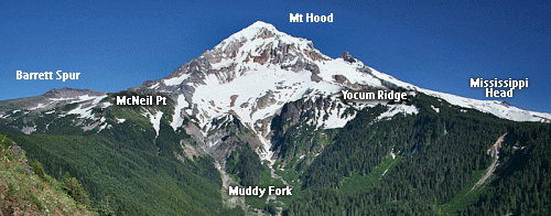
Follow this trail for about another half mile and you will come to a popular viewpoint of the Sandy Glacier on Mt Hood with the Muddy Fork river valley below.

In season this little hike not only offers one of the most incredible views of Mt. Hood, but the surrounding hillside, which is the base of Mt. Baldy, is covered with outrageous wildflowers. I recommend that you do this hike in the afternoon, so the sun will be at your back, giving you the best lighting for a world class photo of a world class mountain.


The following images are random samples of the wildflowers found in the Mount Hood National Forest.
Mouseover image to view flower name, and click on image to jump to flower guide.
Directions:

Take the Lolo Pass Road (Road 18) out of Zig Zag for about 4 miles. Bear right on Road 1825. In about another mile, bear to the left and do NOT cross the bridge over the Sandy River. Follow Road 1828 about 6.5 miles to the junction with Road 118. Bear right on Road 118 and follow it another couple miles to the trailhead. Park head-in on the opposite side of the road from the trail. Vandalism is a problem here... so be aware.

Click on the link below to see a map taking you to the trailhead.

Map Directions


Vicinity Map


To contact the Mt. Hood NF for current information: Click Here.


A Virtual Hike in the Mt Hood National Forest
Click for PDF
Click for PDF