Summary:
Press CTRL + P to print. Photos do not show when you print this page. (Help)
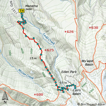
 This excellent hike is listed as difficult because of the vigorous climb that
is required to reach the junction of the Mazama Trail and the Timberline Trail.
Nevertheless this adventure is worth every muscle aching, lung gasping, mosquito
infested step of the way..... only kidding, its really not that bad, and it truly
worth whatever effort required to reach Cairn Basin in summer or fall.
This excellent hike is listed as difficult because of the vigorous climb that
is required to reach the junction of the Mazama Trail and the Timberline Trail.
Nevertheless this adventure is worth every muscle aching, lung gasping, mosquito
infested step of the way..... only kidding, its really not that bad, and it truly
worth whatever effort required to reach Cairn Basin in summer or fall.
I say fall, because I've included some photos of the area taken in the fall, which
will show you just how beautiful that season is at Cairn Basin.
Back to the hike.... So, after you've parked your comfortable SUV at the spacious
trailhead parking lot, the trail wanders mostly level for a bit, kinda giving you
a false sense of what's ahead. Soon you reach the Forest Service sign in "booth"
and you're on your way. The trail begins by climbing abruptly through a large
rocky area. Here you get lots of views of the surrounding area, especially the
shrinking size of that SUV you left behind at the trailhead.
The only significant difference in the trail environment as you climb the Mazama
Trail is altitude. You will wander in and out of dense forests, Rhododendron lined
pathways, and Avalanche Lily gardens.... if the season is right. Otherwise you
just wander.
 After reaching the Timberline Trail, bear left and follow the trail another half
mile to Cairn Basin. In season the trail passes through incredible fields of
Paintbrush, Lupine, and other alpine flowers that can leave you with an entire
roll of pictures of just flowers. There are also lots of views. Other than one
of the most superb views of Mt Hood, there are many vistas that you will want
exposed on your camera's collection format; ie film or CCD.... anyway you look at
it or photograph it, this hike is truly worth it.
After reaching the Timberline Trail, bear left and follow the trail another half
mile to Cairn Basin. In season the trail passes through incredible fields of
Paintbrush, Lupine, and other alpine flowers that can leave you with an entire
roll of pictures of just flowers. There are also lots of views. Other than one
of the most superb views of Mt Hood, there are many vistas that you will want
exposed on your camera's collection format; ie film or CCD.... anyway you look at
it or photograph it, this hike is truly worth it.
By the way, the Mazama Trail is named after the outstanding organization that does
a true labor of love by maintaining this trail in excellent condition! If you
know a member, thank them.
|