Summary:
Press CTRL + P to print. Photos do not show when you print this page. (Help)
 I offer this hike as a separate hike, even though it travels the same trail
and route as the much longer and much more difficult Paradise Loop Hike (Hike 30).
I want to encourage moderate hikers to try just a part of these more difficult
hikes to get a sense of what is out there.
I offer this hike as a separate hike, even though it travels the same trail
and route as the much longer and much more difficult Paradise Loop Hike (Hike 30).
I want to encourage moderate hikers to try just a part of these more difficult
hikes to get a sense of what is out there.
This wonderful little hike begins a the Timberline Lodge parking lot. Just
walk uphill on the paved service road to the east of the lodge to the sign
marked Pacific Crest Trail. Bear left at this point and follow the trail
west through the Mt Hood Ski Area. After about a half mile, you will be out
of the ski area and surrounded by lots of extreme scenery.
The trail wanders up and down through small valleys with snow fed streams.
In season the trail is lined with large amounts of Lupine, Paintbrush, and
Asters. With frequent views of Mt Hood, and Mt Jefferson to the south,
you will never run out of vistas to enjoy.
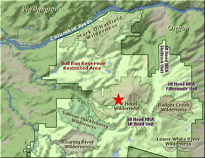
At about a mile you need to sign in as you will now enter the Mt Hood Wilderness.
Soon you come to the junction of the trail to Hidden Lake far below you. The
trail then enters more of a timbered area and does a few small switchbacks as
you descend to your goal.
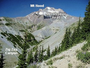
The last few hundred yards is a bit uphill as you climb out of one of the snow
fed valleys and reach the saddle that makes what we call the Zig Zag Canyon Overlook.
If you walk just a bit further, you will find another excellent vantage point where
lots of photos are in order before you begin your climb back up to Timberline Lodge
and that comfy vehicle that brought you here.
|