Summary:
Press CTRL + P to print. Photos do not show when you print this page. (Help)
 First, be aware that it depends on which trailhead you begin your hike as to
whether or not you must have a Northest Forest Pass. Timberline Lodge is the
only place that I'm aware of that you do NOT need a Forest Pass to hike the
Timberline Trail in the summer. Of course, in the winter, you must have a SnoPark Pass.
First, be aware that it depends on which trailhead you begin your hike as to
whether or not you must have a Northest Forest Pass. Timberline Lodge is the
only place that I'm aware of that you do NOT need a Forest Pass to hike the
Timberline Trail in the summer. Of course, in the winter, you must have a SnoPark Pass.
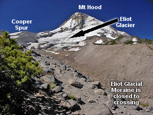
I offer the round the mountain Timberline Trail on this CD hiking guide, but I
want you to keep in mind that due to severe conditions resulting from glacial
melt and movement, the entire circuit around Mt. Hood is not always safe. As
of the writing of this hiking guide, the Timberline Trail across the Eliot Glacier
is considered "Closed" by the forest service. This of course can change from
year to year, so it is best to call them before planning your trip around this
marvelous mountain. At the end of this dialog is the number to call for
current conditions.
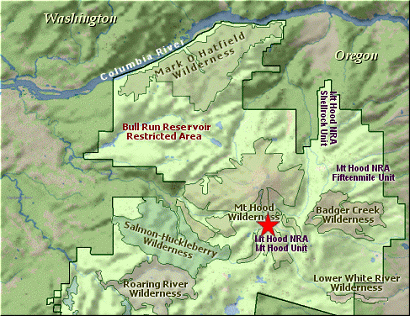
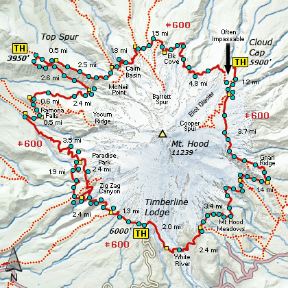
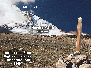
The Timberline Trail #600 is an excellent trail that circles Mt. Hood at or near
timberline, thus its name. The exact mileage of the trail varies a bit, but it
is very near to 39 miles. The trail is almost always very well maintained and in a
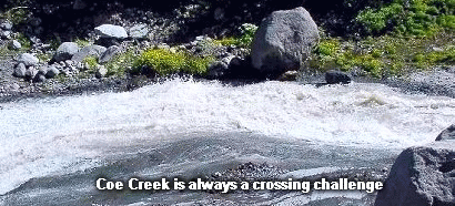
safe condition to hike. The only significant challenge on this trail is the water
crossings. Depending on the time of year, the various run-off rivers and creeks
that flow across this trail vary greatly. Make no doubt about it, the crossing
of these streams can be very dangerous and caution is absolutely essential. Please
take time to read the information available on this CD by clicking the river crossing
information link below.
A hiker can choose his direction of walking the Timberline Trail. Most people
seem to favor beginning at the Timberline Lodge parking lot and hiking west, or
clock-wise. The hike is best done in three days, thus requiring two overnight
stays along the trail. This narrative is not meant to offer a complete detailed
report as to the best places to camp and other various nuances of the hike, but
is intended to simply illustrate the trail for the potential hiker.
 You are strongly encouraged to obtain books that detail the hike and give you the
necessary tips to make the journey an enjoyable adventure. Contact the forest
service or a local book store to find this information.
You are strongly encouraged to obtain books that detail the hike and give you the
necessary tips to make the journey an enjoyable adventure. Contact the forest
service or a local book store to find this information.
From season to season the route around Mt. Hood via the Timberline Trail varies in
its condition and safety. If you are seriously thinking of hiking around Mt. Hood
via this incredible trail, you are well advised to call the Forest Service of drop
in and discuss your plans with them.
For Example:
As of September 2011, this trail is still officially closed by the Forest Service due to the
crossing of Eliot Creek. And in the summer of 2011, the Muddy Creek crossing was considered
dangerous and impassable.
Hood River Ranger District - Hood River Ranger Station
Telephone: 541.352.6002
Also, Click Here for useful suggestions on river crossings.
|