Summary:
Press CTRL + P to print. Photos do not show when you print this page. (Help)
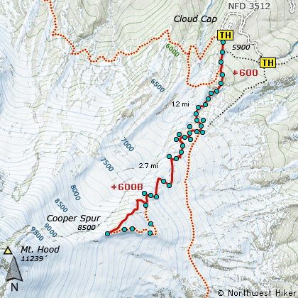
 Now here's a unique hike. Starting at the Cloud Cap camp area, you follow the
Timberline Trail #600 south and uphill. You start out in large high altitude
hemlock. But soon, you break free of any tree called large, and you begin some
serious elevation change. As you walk through dunes of mountain ash and boulders,
you are surrounded by constantly changing vistas. Trail is marked by large piles
of rocks with wood posts sticking out of them.... cairns of a sort.
Now here's a unique hike. Starting at the Cloud Cap camp area, you follow the
Timberline Trail #600 south and uphill. You start out in large high altitude
hemlock. But soon, you break free of any tree called large, and you begin some
serious elevation change. As you walk through dunes of mountain ash and boulders,
you are surrounded by constantly changing vistas. Trail is marked by large piles
of rocks with wood posts sticking out of them.... cairns of a sort.
You will cross a couple of springs that have lush green vegetation. But that's the
last of the water you'll see for a while. You soon climb uphill through a thick
grove of white bark pine and wonderful lupines. Look back over your shoulder for
great views of Mt Adams and Mt Rainier.
At about 1.25 miles you will come to the junction of this Timberline Trail and the
trail from Tilly Jane campground. Bear right at this junction and begin the steady
steep climb up Cooper Spur. In just a short distance notice the old stone shelter
build so long ago to provide protection for mountaineers caught in unfriendly weather.
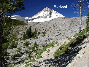
The vistas just keep getting better.
 In about a mile, the trail will bring you right to the edge of the Eliot Glacier moraine. Here
you can enjoy some of the most unique views anywhere. By now you are way above
timberline and the only flowers are a few hardy alpine species that somehow survive
up here. I believe one of them is called partridge foot. Another looks like a
miniature aster.
In about a mile, the trail will bring you right to the edge of the Eliot Glacier moraine. Here
you can enjoy some of the most unique views anywhere. By now you are way above
timberline and the only flowers are a few hardy alpine species that somehow survive
up here. I believe one of them is called partridge foot. Another looks like a
miniature aster.
The remaining mile is very steep. Lots of switchbacks and often a large snowfield blocks
the last quarter mile of the trail. It is best to just scramble up the side of the hill
to the summit of Cooper Spur. Once you arrive, you'll see many shelters built by folks
wanting to stay overnight out of the wind. The sky at this elevation is almost black.
The views on a clear day are just as extreme. This hike is more than worth the effort.
|