MOVE MOUSE OVER MAP CAMERA ICONS ( ) TO VIEW PHOTOS - F5 TO REFRESH ) TO VIEW PHOTOS - F5 TO REFRESH
A PICTURE IS WORTH A THOUSAND WORDS


TRAIL POSITIONED PHOTOS OF THE HIKE |
NOT TO BE USED FOR NAVIGATIONAL PURPOSES - ONLY FOR REFERENCE
 |
|
|
|
| Hike Length: |
9.2 miles round trip |
| Elev. Change: |
2000' gain |
| Hike Difficulty: |
Challenging |
| Season: |
Summer thru Fall |
|
| Trail Condition: |
Good to Fair |
| Trail Access: |
Good |
| Trail Signage: |
Good |
| Features: |
Views, Wildflowers, Alpine |
|
| Useage: |
Light |
| Permit: |
NW FP Required |
| Horses: |
No |
| Mtn Bikes: |
No |
|
|
Summary:
Press CTRL + P to print. Photos do not show when you print this page. (Help)

Note:
As of September 2011,
this trail is considered
closed by the Forest
Service due to the
crossing of Eliot Creek.
|
Did I say Challenging? OK... well, that's an understatement. Note that the elevation
difference between your starting point and destination is only a couple hundred feet.
And the mileage is only 9.2 round trip. Well, stick those numbers in the ol Hike
Difficulty Calculator and see what you get....moderate??? Hummmm, then where do I get
the 2000' feet of elevation gain?? Did I use the word CUMULATIVE? Oh yes, did I
mention that this trail climbs and descends, and climbs and descends, and cli..... oh,
you get the point.
 To make matters more interesting, mother Nature has managed to make crossing some of
the streams nearly impossible, so our fine Forest Service has created a detour to help
us survive this adventure. This adds even more up and down to the afore mentioned
2000 feet of elevation gain, so I'd say one really needs to refer to this hike as
Challenging.
To make matters more interesting, mother Nature has managed to make crossing some of
the streams nearly impossible, so our fine Forest Service has created a detour to help
us survive this adventure. This adds even more up and down to the afore mentioned
2000 feet of elevation gain, so I'd say one really needs to refer to this hike as
Challenging.
I know, enough already, let's talk the hike. OK, so let's say you begin the hike
at the Cloud Cap camp area. At the writing of this narrative, the trail is closed
across Eliot Creek, so one must use the Detour UPHILL and cross the creek where it is
reasonably safe and where the Forest Service has installed a bridge. Follow the
signs and pink ribbons to this safety feature and back to the original trail to
Elk Cove.
Don't be discouraged. This hike is as much fun to make fun of as it is to hike. I
hike this particular hike almost every year and I never get tired of the outstanding
scenery, and I actually enjoy the adventure of wondering just how I'm going to get
across the creeks "this year".
The trail descends gently for several miles through a variety of environments. Sometimes
you are in dense high mountain forests, and other times you are out in the open with
some of the best views in town. On a clear day you can see almost forever. And in
season, the flowers don't get much better anywhere than on this hike to Elk Cove.
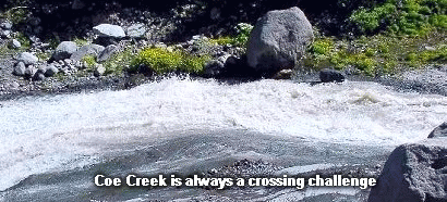 About a half mile from your destination, you must cross Coe Creek. Sometimes this is
a difficult challenge. Whatever you do, DO NOT ATTEMPT SOMETHING BEYOND YOU ABILITY LEVEL.
It just isn't worth falling in the creek or injuring yourself. However, I've always
been able to find the right combination of rocks and logs to get across this fast
moving stream.
About a half mile from your destination, you must cross Coe Creek. Sometimes this is
a difficult challenge. Whatever you do, DO NOT ATTEMPT SOMETHING BEYOND YOU ABILITY LEVEL.
It just isn't worth falling in the creek or injuring yourself. However, I've always
been able to find the right combination of rocks and logs to get across this fast
moving stream.

When you get to Elk Cove, you will consider the effort well worth it. When you get back
to your vehicle at the parking lot at Cloud Cap, you may have different thoughts. Hopefully
not. Hopefully, this hike will be a wonderful adventure filled with all the good stuff
an adventure should have, including a happy ending... and a fun story to share with your
family and friends.
Now, a word about hiking from Cloud Cap to Elk Cove. Because at the time of this writing,
the trail is officially closed, the only other viable alternatives to getting to Elk Cove
are from the west. And there are many options from the west. Vista Ridge
and Pinnacle Ridge are two excellent options, but possibly the best choice,
which I do not have on this hiking guide is the Coe Ridge trail.
For current road/trail conditions call the
Zigzag Ranger Station: 541.352.6002
Also, Click Here for useful suggestions on river crossings.
|
|
The following images are random samples of the wildflowers found in the Mount Hood National Forest.
Mouseover image to view flower name, and click on image to jump to flower guide.
|
Directions:
Follow Oregon Hwy 35 south of Hood River or
north from Hwy 26 near Government Camp until
you come to Road 3510 indicating the Cooper
Spur Ski area and Resort. Follow Road 3510
for a couple of miles and at the resort you
will see Road 3512 to Cloud Cap clearly
marked. Follow this road for about 10 miles
to the junction to Tilly Jane campground.
Bear right at this point and arrive at the
trailhead about a mile later.
Click on the link below to see a map taking you to the trailhead.
|
|
|


