Summary:
Press CTRL + P to print. Photos do not show when you print this page. (Help)
 Now this is the way to climb Lookout Mountain. I mean, there are several ways to climb
the mountain, and this CD offers 3 options. But, to me, this is the true Lookout Mtn
climb. You park at a fine trailhead and follow a trail designed to take you to the
top of this fine peak. You don't walk on roads (well, maybe the last 100 feet) and
you don't have to piece together other trails to make it work. You just hike and
enjoy the excellent eastern Oregon environment as you ascend this outstanding vista.
Now this is the way to climb Lookout Mountain. I mean, there are several ways to climb
the mountain, and this CD offers 3 options. But, to me, this is the true Lookout Mtn
climb. You park at a fine trailhead and follow a trail designed to take you to the
top of this fine peak. You don't walk on roads (well, maybe the last 100 feet) and
you don't have to piece together other trails to make it work. You just hike and
enjoy the excellent eastern Oregon environment as you ascend this outstanding vista.
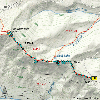
The trail begins in a mountain meadow and for the most part slowly climbs the 1100' or
so that you need to reach the summit. There are a couple of steeper parts and just before
the junction to Oval Lake you will descend a bit.... elevation that you need to reclaim
on your way to the top. At about a mile you will begin to walk along cliffy areas that
offer ever expanding views. The higher you climb of course the grander the offering of
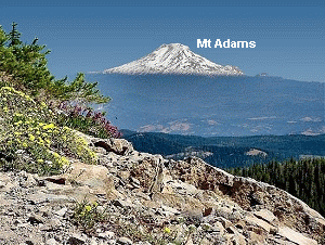
vistas. You will be able to see Mt Jefferson to the south
and eventually you will have
outstanding views of Mt Adams, Mt Rainier,
and Mt St Helens to the north.
 But, of course, the main attraction from the top of Lookout Mtn is Mt Hood. This easterly
view presents another of the varied silhouettes of this wondrous peak.
But, of course, the main attraction from the top of Lookout Mtn is Mt Hood. This easterly
view presents another of the varied silhouettes of this wondrous peak.
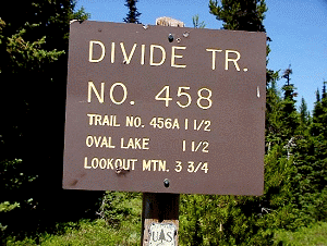
 This trailhead to Lookout Mountain is located just a short distance from Flag Point,
which has a fire lookout tower on it. This tower can be rented.
This trailhead to Lookout Mountain is located just a short distance from Flag Point,
which has a fire lookout tower on it. This tower can be rented.
Click Here to learn more about this feature.
|