Summary:
Press CTRL + P to print. Photos do not show when you print this page. (Help)
This is a long and steep hike. The hike begins to ascend almost
immediately and climbs along the side of a steep hillside within a dense forest. About
half way to the Gumjuwac viewpoint you get your first glimpse of Mt Hood, mostly visible through
the trees. Then as you round the corner to the viewpoint itself, you are treated to outstanding views
of Mt Hood and the valley below. The trail then enters the dense forest
again and remains in the forest until you break out at Gumjuwac Saddle and Forest Road #3550.
You cross the road and bear to the left to follow Trail #458 toward Lookout Mountain.
At this point you begin to be in more open areas where wildflowers abound. As you switchback
your way up Lookout Mountain you get increasingly great views both to the west with Mt Hood
and to the south with Mt Jefferson, the Three Sisters, and Badger Lake. Near the ridge top
you encounter various other trails that approach Lookout Mtn from differing trailheads.
Continue on this divide trail to the summit where there used to be a fire lookout. The
panoramic views are truly worth the effort to get here.
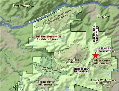
Having said that, note that the map shows another approach to Lookout Mtn from the north.
This is the High Prairie trailhead and is obviously a much short and less vigorous hike.
The following images are random samples of the wildflowers found in the Mount Hood National Forest.
Mouseover image to view flower name, and click on image to jump to flower guide.
Whether you approach this from on Hwy 35
going south out of Hood River, or if you
are coming north from Hwy 26 near Government
Camp, watch for the bridge near what was
the Robin Hood Campground.
The trailhead is on the east side of the
road and on the north side of the bridge.
Click on the link below to see a map taking you to the trailhead.