Summary:
Press CTRL + P to print. Photos do not show when you print this page. (Help)
 There are a number of ways to reach the summit of Tumala Mountain, formerly known as
Squaw Mountain. One way is to hike up Forest Road 180 off Forest Road 4610. The other
two ways on are on this CD. This Hike 64 will describe the approach from the west,
beginning at the trailhead for Old Baldy which is accessible via Forest Road 4614.
There are a number of ways to reach the summit of Tumala Mountain, formerly known as
Squaw Mountain. One way is to hike up Forest Road 180 off Forest Road 4610. The other
two ways on are on this CD. This Hike 64 will describe the approach from the west,
beginning at the trailhead for Old Baldy which is accessible via Forest Road 4614.
Parking is very limited at this trailhead, but you can park along FR4614 as it has a
wide shoulder near this trailhead. There are two large boulders that indicate the
beginning of the trail. There is actually a third way to get to Tumala Mountain via
FR4614, by accessing a trail a half mile or so before this spot. Notice on the map
a dotted line from the curved area west of here and traveling to Trail #502 midway to
Tumala Mountain. I have not hiked this option but am certain that it is a viable alternative.
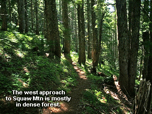
As you begin the hike from FR4614 trailhead as I present it on the above map, you will
almost immediately come to a junction to a trail that goes down a ridge and into the Eagle
Creek drainage. When you pass this junction, Trail #502 gets extremely steep. For the
next quarter mile the trail climbs abruptly as it works its way over a ridge then back
down to follow that ridge line to Tumala Mountain. The trail is in good but not great
condition. Within a half mile you will meet the trail I mentioned earlier as an alternate
route. Keep on straight ahead as the trail climbs increasingly more abruptly as you near
the Tumala Mountain ridge itself.
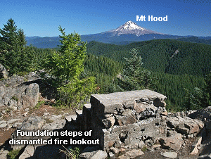 At the saddle, you come to the other trail featured on this CD, Hike 65, which brings you
to Tumala Mountain from the east. At this point it is a short climb to the ridge line where
you begin to get the first of many incredible views of Mt.Hood to the northeast. After a
brief steep switchback climb, the trail comes out onto abandoned Forest Road 180. Bear left
and walk this road to the parking area near the summit of Tumala Mountain. The mountain did
have a fire lookout tower for many years, but it has since been removed. Only the concrete
steps remain of the old tower.
At the saddle, you come to the other trail featured on this CD, Hike 65, which brings you
to Tumala Mountain from the east. At this point it is a short climb to the ridge line where
you begin to get the first of many incredible views of Mt.Hood to the northeast. After a
brief steep switchback climb, the trail comes out onto abandoned Forest Road 180. Bear left
and walk this road to the parking area near the summit of Tumala Mountain. The mountain did
have a fire lookout tower for many years, but it has since been removed. Only the concrete
steps remain of the old tower.
You will see a couple of opportunities to walk from the old parking area to the ridge line
itself. I took the first one, and as I came up onto the ridge, wow... talk about a view.
This is one of the most beautiful views of Mt. Hood available from the southwestern part of
the Mt. Hood National Forest. When you look toward Mt. Hood, you are looking at forests
of unparalleled beauty and symmetry. Then as you look to the southeast, you can see Mt. Jefferson.
Walk the ridge and explore all the little view options as you follow little user trails.
This is truly a fantastic short hike, either way you choose to get there.
Enjoy!
|