Summary:
Press CTRL + P to print. Photos do not show when you print this page. (Help)
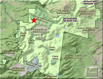
 There are a number of ways to reach the summit of Tumala Mountain, formerly known as
Squaw Mountain. Hike 64 describes the approach from the west, beginning at the trail
head for Old Baldy which is accessible via Forest Road 4614. Another way is to hike up
Forest Road 180 off Forest Road 4610. This Hike 65 begins at the Twin Springs trail
head off Forest Road 4610.
There are a number of ways to reach the summit of Tumala Mountain, formerly known as
Squaw Mountain. Hike 64 describes the approach from the west, beginning at the trail
head for Old Baldy which is accessible via Forest Road 4614. Another way is to hike up
Forest Road 180 off Forest Road 4610. This Hike 65 begins at the Twin Springs trail
head off Forest Road 4610.
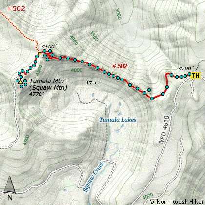
The parking area and trailhead are well marked, but parking is limited and you may
have to walk a bit if you can't park right at the trailhead itself. Just a hundred
feet or so after you begin this hike, you will come to a junction in the trail. To
the right Trail #783 takes you to Huckleberry Mountain near Welches, but you need to
bear left on the Old Baldy Trail #502. (By the way, #502 is incorrectly labeled #783 on
the Topo Map.)
This trail was in surprisingly good condition and well maintained. The trailhead actually
sits in a saddle, so as you start your hike toward Tumala Mountain you begin climbing out
of the saddle almost immediately. The trail contours over a bit of ridge and then begins
a gentle descent to another saddle. At this saddle you can scramble off the trail for just
a short distance and up a ridge line where you get excellent views to the north and Wildcat Mountain.
 Back on the trail, you will continue slightly downhill for a ways until you break out into
a more open area. Here you catch your first glimpses of Tumala Mountain and the surrounding
hills and valleys. Below you are Tumala Lakes (formerly known as Squaw Lakes). The trail
continues to parallel a ridge line on your right, but eventually comes out onto the ridge.
However, by this time you are in a dense young forest and it will remain this way until you
get to the Tumala Mountain ridge.
Back on the trail, you will continue slightly downhill for a ways until you break out into
a more open area. Here you catch your first glimpses of Tumala Mountain and the surrounding
hills and valleys. Below you are Tumala Lakes (formerly known as Squaw Lakes). The trail
continues to parallel a ridge line on your right, but eventually comes out onto the ridge.
However, by this time you are in a dense young forest and it will remain this way until you
get to the Tumala Mountain ridge.
Having descended a fair amount, the trail will now take you through a series of steep
switchbacks, trying to regain the elevation and put you on Tumala ridge. At about 1.7
miles, you will come to a major junction with Trail #520, which is the other approach
to Tumala Mountain as described on Hike 64. Bear left and climb up onto the ridge line
where you will begin to enjoy incredible views of Mt. Hood and Mt. Jefferson. However,
the trail goes back into the dense young forest and after a couple very steep switchbacks,
brings you out onto old abandoned Forest Road 180. Now bear left and follow the old
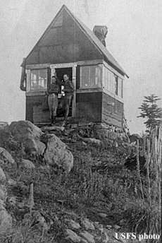
road up into a parking area that used to be used to service the fire lookout that used
to sit on Tumala Mountain.
 From this parking area you can see several user trail approaches to the open ridge line.
If you take the very first approach you will come out onto a rather rocky ridge line with
outrageous views. Walk to the left for a bit so you can get the best views of Mt Hood.
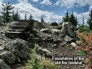
Then walk back, south, along the ridge line until you come to the foundation of the old
fire lookout. You can walk even a bit further and catch some views to the west-southwest.
All in all, this mountain provides exhillerating views of the cascade volcanos, from Mt Hood
to the northeast to Mt. Jefferson to the southeast. This hike is a winner which ever
approach you choose. Enjoy!
From this parking area you can see several user trail approaches to the open ridge line.
If you take the very first approach you will come out onto a rather rocky ridge line with
outrageous views. Walk to the left for a bit so you can get the best views of Mt Hood.
Then walk back, south, along the ridge line until you come to the foundation of the old
fire lookout. You can walk even a bit further and catch some views to the west-southwest.
All in all, this mountain provides exhillerating views of the cascade volcanos, from Mt Hood
to the northeast to Mt. Jefferson to the southeast. This hike is a winner which ever
approach you choose. Enjoy!
|