Summary:
Press CTRL + P to print. Photos do not show when you print this page. (Help)
 This is a gentle, family oriented style hike. The only real challenge of this hike
is the getting there. You will have to drive through a small stream, but I would
imagine that most of the time and with most cars this is not a serious problem. Nevertheless,
please be advised that you may not feel that way when you come upon this crossing.
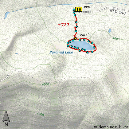
This is a gentle, family oriented style hike. The only real challenge of this hike
is the getting there. You will have to drive through a small stream, but I would
imagine that most of the time and with most cars this is not a serious problem. Nevertheless,
please be advised that you may not feel that way when you come upon this crossing.
It is only about a mile from the trailhead to the lake. The trail starts out pretty steep,
but doesn't stay that way for long. As you come upon the lake, you approach an area that
people have used for camping. Walk straight through this campsite and you will come to the
lake's edge.
This is another lake in the Mt. Hood National Forest that does not have a great shoreline.
However, a primitive trail does encircle the lake and from time to time bring you to the
shore for great views and access. There are occasional camping areas around the lake also.
I would imagine that in season, this lake offers its share of mosquitos and other pesty flies.
So come prepared.
|