Summary:
Press CTRL + P to print. Photos do not show when you print this page. (Help)
 (Please note that the photos supplied for this hike were taken by my close
personal friend, Terry Hill. I was unable to do this hike, but my friend, Terry, did
it for me and photographed it for me. Thanks to him, I can offer you this hike.)
There are two ways to hike the perimeter trail of Trillium Lake; either clockwise or
counterclockwise. If you are a serious photographer, the direction you choose will
be determined by where the sun will be when you arrive at those points you want to
photograph.
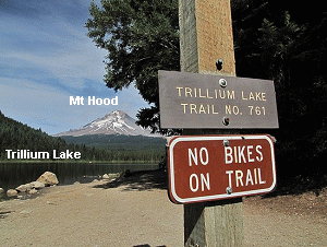
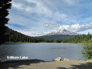
The trailhead we used was on the eastern corner of the dam. They have created an apron
on the lake side of the dam for fishermen and other visitors to just enjoy the lake and
the unbelievable image of Mt. Hood rising to the northeast in all its splendor. I chose
that photo to put on the cover of this CD as well as the intro page.
 Trillium Lake can be accessed year round, however, in the winter you will have to leave your
vehicle at the Hwy 26 snow park area. My friend Terry and I snowshoed in last winter and it
was a wonderful experience in spite of the distance. We passed folks on snowshoes, cross-country
skis and just plain walking in hiking boots.... and they all seemed to be having a wonderful time.
Trillium Lake can be accessed year round, however, in the winter you will have to leave your
vehicle at the Hwy 26 snow park area. My friend Terry and I snowshoed in last winter and it
was a wonderful experience in spite of the distance. We passed folks on snowshoes, cross-country
skis and just plain walking in hiking boots.... and they all seemed to be having a wonderful time.
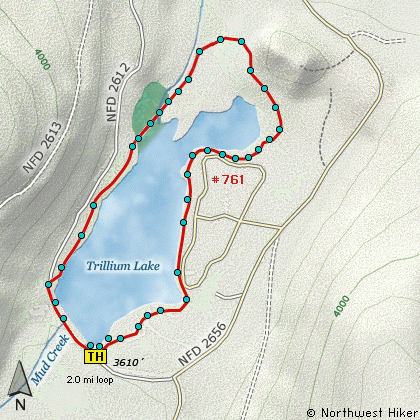
The mouse-over photos on the map above speak of the hike around the lake. Because I didn't actually
do this hike, I too rely on the images to form my opinion about hiking around the lake.... and I am
really looking forward to the day that I can. I hope you enjoy it as much as my friend did.
|