Summary:
Press CTRL + P to print. Photos do not show when you print this page. (Help)
 (Please note that the photos supplied for this hike were taken by my close
personal friend, Terry Hill. I was unable to do this hike, but my friend, Terry, did
it for me and photographed it for me. Thanks to him, I can offer you this hike.)
Just like Trillium Lake, the perimeter of this lake obviously can be hiked either
clockwise or counterclockwise. Now, due to the length of this hike, I would recommend
hiking the loop counterclockwise. That way the sun will most likely be behind you.
For those of you who use a polarizing filter on your camera, the angle of the sun will matter.
My friend began the hike at the southeastern corner of the lake at the Oak Fork campground
boat launch. The trail runs right through the area, and is well signed. Just head east and
soon you will cross a bridge over Oak Grove Fork of the Clackamas River, then meet up with the Pacific Crest Trail. You
will walk the PCT along the eastern lake shore for the next few miles until you cross another
bridge which takes you over Crater Creek as it runs into Timothy Lake.
 After you cross over the bridge, the trail junctions. The PCT continues on north, but you
need to take the sharp left turn and continue your journey around the lake. You will cross
other bridges and swampy areas, but eventually you will come out to an area that you can
actually drive to. Here is where North Arm Campground is located. Just follow the trail
on through the area and it continues to lead you around the lake. This area passes through
what we call open range, and it is entirely possible that you
will encounter some free ranging cattle.
After you cross over the bridge, the trail junctions. The PCT continues on north, but you
need to take the sharp left turn and continue your journey around the lake. You will cross
other bridges and swampy areas, but eventually you will come out to an area that you can
actually drive to. Here is where North Arm Campground is located. Just follow the trail
on through the area and it continues to lead you around the lake. This area passes through
what we call open range, and it is entirely possible that you
will encounter some free ranging cattle.
 In a couple of more miles you will come to another junction. This is the spur trail that
will take you out on Meditation Point. It is well worth the extra minutes to walk
out on this narrow peninsula and enjoy the extraordinary views of Timothy Lake. There are
also restroom facilities here, and picnic benches.... a great place to R & R before continuing
on your journey around the lake.
In a couple of more miles you will come to another junction. This is the spur trail that
will take you out on Meditation Point. It is well worth the extra minutes to walk
out on this narrow peninsula and enjoy the extraordinary views of Timothy Lake. There are
also restroom facilities here, and picnic benches.... a great place to R & R before continuing
on your journey around the lake.
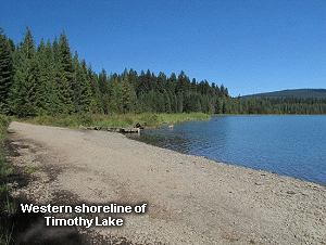
After returning to the main trail, it is another couple of miles to the west side trailhead. From
here you will simply walk the road, cross over the dam, and then find the trail on the east end of
the dam. At this point you have about two and a half miles to walk in order to reach the place
where you began. Nearly all of this part of the hike is close to the lake shore and offers ever
increasingly beautiful scenery. I say that because in about a mile you will begin to see Mt. Hood
to the north-northwest. There will be a window of opportunity right in the middle of this section
to get great photos of Mt. Hood. As you complete your adventure, the mountain will be obscured by
hills nearer to you.
This is a wonderful hike, and I highly recommend it. Even though I did not do the entire hike, I
did do the entire south shore. And even that was sooooooo worth it. Enjoy!

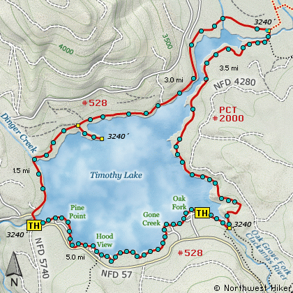
By the way, as far as whether or not you can ride a bike along this trail, or a horse for that
matter, take a look at the graphic to the left and see if you can make sense out of it. It appears
with a couple minor detours, you can ride a bike completely around the lake, but it looks like horse
are not welcome along the south shore. But, I'm sure it can be done by simply riding along the road
when you cross the dam, rather than along the shore and campground areas.
|