Summary:
Press CTRL + P to print. Photos do not show when you print this page. (Help)
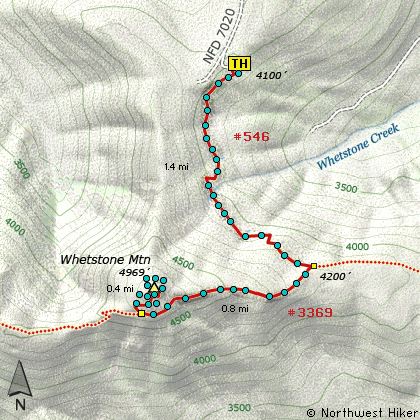
 This hike shares the same trailhead as the western approach to
Twin Lakes and the hike
to Silver King Lake.
The first mile and a half are exactly the same trail, but when you climb up onto the
ridge, and come to the junction to Trail #3369, bear a sharp right and follow this
trail to the base of Whetstone Mountain. As you leave the trailhead parking area,
the trail descends into a forest of large, probably old growth timber. Depending on
the season, it can be damp through this part of the hike, but the trail soon climbs
in a series of steps to higher, drier ground.
Although you will come upon a small tarn, there are few water sources to negotiate. After
the tarn, the trail climbs rather steeply until it reaches the junction of Trail #3369. As
mentioned, bear a sharp right onto Trail #3369 and head west along the ridge toward Whetstone
Mountain.
Trail #3369 actually goes all the way to the North Fork of the Santiam River at the bottom of the canyon, but you will
only want to follow it as far as the junction to the trail that takes you to the summit of
Whetstone Mountain. The trail climbs steadily along the ridge and wanders through mostly dense
forests of fir and hemlock. It is less than a mile from the junction to the next junction,
which connects to the summit trail. Bear right and follow the steep incline through a series
of switchbacks and occasional viewpoints until you reach the summit. As is common, this
mountain also once had a fire lookout on top of it and the foundation is still there.
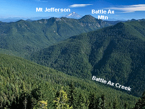 The views you are privileged to enjoy are off the charts. There is Mt. Hood to the north, and then
the peaks of the Bull of the Woods Wilderness, of which Whetstone is one. Then to the east there
is Olallie Butte and south of it is Mt. Jefferson. On a really clear day you can see the top of
Three Fingered Jack, Mt. Washington, and the Three Sisters. Below you to the south is Battle Ax
Creek and further to the southwest is Opal Creek. Both of these creeks form the North Fork of the
Santiam River.
The views you are privileged to enjoy are off the charts. There is Mt. Hood to the north, and then
the peaks of the Bull of the Woods Wilderness, of which Whetstone is one. Then to the east there
is Olallie Butte and south of it is Mt. Jefferson. On a really clear day you can see the top of
Three Fingered Jack, Mt. Washington, and the Three Sisters. Below you to the south is Battle Ax
Creek and further to the southwest is Opal Creek. Both of these creeks form the North Fork of the
Santiam River.
Of course you return to the trailhead the same way you got here. Enjoy!
|