Summary:
Press CTRL + P to print. Photos do not show when you print this page. (Help)
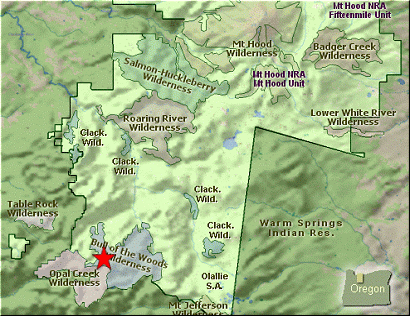
There are several ways to get to Silver King Lake. One is by taking the trail from Bagby
Hot springs. Another is by hiking in from Elk Lake. But the one I'm presenting begins
at the Whetstone Mountain trailhead and follows the ridge between Whetstone Mtn and
Silver King Mtn. The trailhead access is easy and the hike is spectacular.
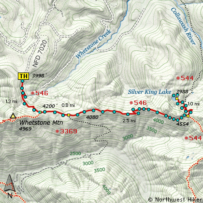
The trail descends immediately from the parking area, passing the Check Point Charlie on
the way.... poop shovels and all! You lose a bit of altitude here as you cross this
little valley and approach the ridge that you will follow almost to the lake.
When you reach the top of the ridge you will intersect Trail #3369 coming in from the west.
This trail follows your Trail #546 for nearly a mile before dropping down into the valley
below. You will climb and descend several times during this hike, but none of the changes
are very great. At about two miles you begin to be more out in the open and the views
are just great. This a beautiful wilderness area and this hike provides you so many vistas
to enjoy it.
At about four and a half miles you will come to a saddle where the trail down to Silver King
Lake branches off to your left. Follow this Trail #544 downhill to the spur trail that takes
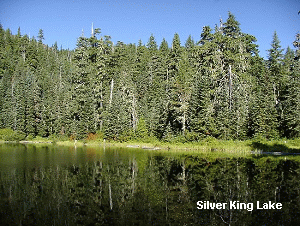
you back uphill a bit to the lake itself. Silver King is a small but beautiful lake and worth
the journey.
The following images are random samples of the wildflowers found in the Mount Hood National Forest.
Mouseover image to view flower name, and click on image to jump to flower guide.
Follow Hwy 224 southeast of Estacada approximately 25 miles until it becomes
Forest Road 46 just after the Ripplebrook Ranger Station and the junction with
Forest Road 57. Continue south for about another 3.7 miles to the junction
with Forest Road 63. Bear right onto FR 63 and cross over the Clackamas River.
The road now follows the Collawash River for approximately 3.5 miles until you
come to the junction with Forest Road 70.
Turn right onto FR 70, which is the same road that takes you the Bagby Hot Springs area.
Continue for approximately 6.5 miles past the Bagby Hot Springs parking area
to the junction with Forest Road 7020. Turn left onto FR 7020 which will take you
steeply up a rather rough road. At times you might think that you are on the wrong
road. Actually, you might wonder if you are on a road... but be assured, it gets
better. It is about 5.5 miles to the trailhead. Just before the trailhead
you will pass the junction to Forest Road 7030, but keep straight ahead.
Click on the link below to see a map taking you to the trailhead.