Summary:
Press CTRL + P to print. Photos do not show when you print this page. (Help)
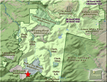
 Even though the road is rough, this is one of the most fantastic
hikes in the Mt Hood National Forest as well as the Bull of the Woods Wilderness.
Even though the road is rough, this is one of the most fantastic
hikes in the Mt Hood National Forest as well as the Bull of the Woods Wilderness.
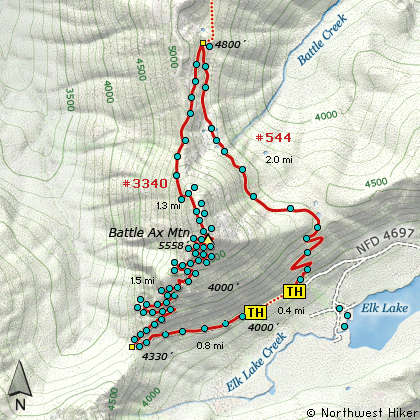
Forest Road 4697 brings you to the starting point of this hike. Or another way to
put it is, FR4697 comes to an abrupt end due to a washout, so you have to start
hiking whether you want to or not. But what the hay, walking uphill on an old
roadbed is likely easier than a trail, because once you reach the saddle between
Battle Ax Mtn and Mt Beachie, you leave what was a road and enter what is a trail.
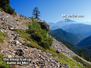
Personally, I love the trail up Battle Ax. Sure it is steep, but the views that are
yours to enjoy almost every inch of the way are so spectacular, that who has time to
worry about where your next breath is coming from.... just take another picture!!!
The trail climbs and climbs and your eyes nearly wear out for all the unbelievable
scenery you are forced to endure. If you don't run out of film on this hike, you
never will. Switchback after switchback you climb. Every foot of elevation gained
brings more tremendous views. At this point I could care less about that treeless
rut called a road that brought me here. I could care less about the steep exhausting
climb. My only concern is whether or not any one up here knows CPR!!!!
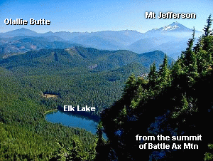 Oh, it is so worth it. There used to be a lookout on the top, so the foundations
are still showing, but who cares and who has time to look at them, with millions
of vistas surrounding you on 360 degrees.... just enjoy, and be glad you're alive.
This hike you will never forget, even when you get out of intensive care.... I promise.
Oh, it is so worth it. There used to be a lookout on the top, so the foundations
are still showing, but who cares and who has time to look at them, with millions
of vistas surrounding you on 360 degrees.... just enjoy, and be glad you're alive.
This hike you will never forget, even when you get out of intensive care.... I promise.
An alternative route back is to walk the ridge to the north of the summit and follow
this trail down until it meets up with Trail #544 to Twin Lakes. Make a hard right
turn south on the trail and follow it back to the road where you are parked. You
will have to walk just a short distance up the road to get back to your vehicle. But
this is truly a fun way to return and adds to the adventure... and isn't as steep
as just going back down the way you got up here.
|