Summary:
Press CTRL + P to print. Photos do not show when you print this page. (Help)
 Here is an exceptional, yet easily overlooked hike, because it follows an
access road to a functional fire lookout tower. Sisi Butte is a prominent
shield volcano. Glaciers have carved the northeast flank and left
moraines strung out to the north and east.
Here is an exceptional, yet easily overlooked hike, because it follows an
access road to a functional fire lookout tower. Sisi Butte is a prominent
shield volcano. Glaciers have carved the northeast flank and left
moraines strung out to the north and east.
Parking is limited, and please don't park in such a way as to block
the roadway in front of the gate. After parking, just hike up the
road to the summit of Sisi Butte.
In season there are a variety of beautiful wildflowers along the
road which add to the joy of this delightful little hike. At first
the road travels in rather dense forest with very few views. But
after about two miles, there are more and more opportunities to
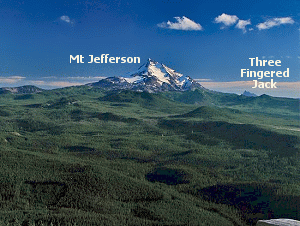
see to the north and the south. If you step off the road on the
south side in more open areas, you can catch exceptional views of
Mt. Jefferson and Olallie Butte.
It is about three miles to the lookout tower on the western peak of Sisi Butte.
There is an eastern summit which is nearly the same elevation. An abandoned
road heads that way before you reach the lookout tower, but it isn't worth
the effort to find the top of the eastern summit. The views and fun are here
on the summit with the tower.
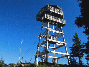 You are welcome to climb to the view area surround the octagon shaped tower.
This structure was built in 1996 and is an active facility in times of
extreme fire danger.
You are welcome to climb to the view area surround the octagon shaped tower.
This structure was built in 1996 and is an active facility in times of
extreme fire danger.
Click Here to view more information on this and other fire lookout towers.
|