Hike 95 Lookout Mountain
via High Prairie
Main Menu
Previous Hike Northern Hikes Mt Hood Hikes SE Central Hikes SW Central Hikes Southern Hikes Hike List Next Hike
MOVE MOUSE OVER MAP CAMERA ICONS () TO VIEW PHOTOS - F5 TO REFRESH
A PICTURE IS WORTH A THOUSAND WORDS


TRAIL POSITIONED PHOTOS OF THE HIKE
NOT TO BE USED FOR NAVIGATIONAL PURPOSES - ONLY FOR REFERENCE
Print Topo Map Hike Difficulty
Calculator
 
Legend Ten Essentials  

Hike Length: 2.5 miles round trip
Elev. Change: 525' gain
Hike Difficulty: Moderate
Season: Summer thru Fall
Trail Condition: Abandoned Road
Trail Access: Good
Trail Signage: Good
Features: Views, Wildflowers, Summit
Useage: Moderate
Permit: NW FP Required
Horses: Yes
Mtn Bikes: No

Summary:
Press CTRL + P to print. Photos do not show when you print this page. (Help)

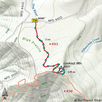
The hike to Lookout Mountain from High Prairie is a moderate hike only because of the elevation gain in the short mile and a quarter hike. Yet it is an easy, family and pet friendly hike, which follows an old abandoned road all the way.

The trail never gets very steep, however in early summer it almost always has some snow in the shaded areas and at the ridge line where the snow drifts deeply. It is at the ridge line where this road meets the other common trail to Lookout Mountain, which begins at Gumjuwac Saddle or at highway 35 below.

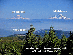
This is the most gentle approach to Lookout Mountain, and therefore makes the mountain available to most hikers. On a clear day the views from the summit are fantastic and so worth the hike, regardless of which trail you chose to get there.


The following images are random samples of the wildflowers found in the Mount Hood National Forest.
Mouseover image to view flower name, and click on image to jump to flower guide.
Directions:

From Hood River, drive south on Hwy 35 approximately 26.5 miles to Forest Road 44 to Dufur. Turn left onto FR 44 and drive about 3.8 miles to a sharp right hand bend in the road, and immediately after the turn Forest Road 4410 will be on your right. Follow FR 4410 for about 4.7 miles south to where it junctions with FR 4420. Turn left and travel east just a short distance to the trailhead for Lookout Mountain.

Click on the link below to see a map taking you to the trailhead.

Map Directions


Vicinity Map


To contact the Mt. Hood NF for current information: Click Here.


A Virtual Hike in the Mt Hood National Forest
Click for PDF
Click for PDF