Hike 01
The Columbia River Gorge National Scenic Area
Rooster Rock Park Hike
Search West Hikes West Central East Central East Hikes
Home Page
Main Map


Click to view product details

THE FOLLOWING MAP IS NOT TO BE USED FOR NAVIGATIONAL PURPOSES. Rooster Rock State Park hike map
Map of Rooster Rock State Park hike

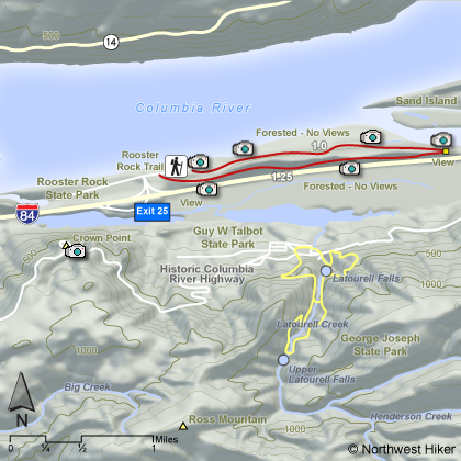
Length: 2.25 miles from Trail Head to Trail Head
Elevation Change: 50' gain
Season: Year Round
Difficulty:   Easy
Permit: No NW Permit, But you must pay a fee to enter the park
GPS:   N45 32.807 W122 14.124
Features:


NEW!
 Click for PDF Topo Map of this Hike 

This hike begins and ends in a parking lot.  The trail runs the length of the Rooster Rock State Park to the east and returns by a loop.  There is very little elevation change, and very limited views.  Please note that the area along the trail on the banks of the Columbia River is designated a " nude beach " area. Also, in spring and summer be very careful for the stinging nettle along the trail!


Columbia River Gorge from Crown Point

How to get there:

Take Interstate 84 to Exit #25, and follow the signs to the Rooster Rock State Park.


Hike Difficulty Calculator

Calorie Burn Calculator

The 10 Essentials
Bear Encounters

Cougar Encounters

River Crossing Safety
A Virtual Hike of the Columbia River Gorge National Scenic Area


Click to View Instructions