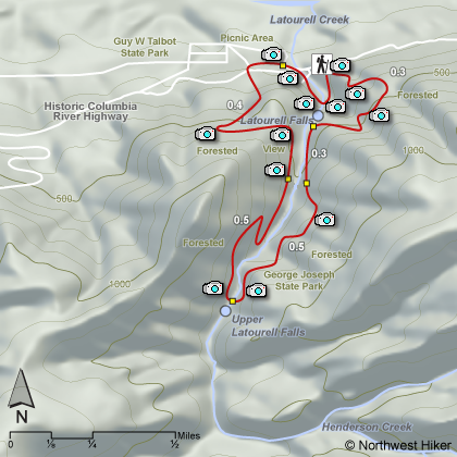
Click to Return Home

Click to Return to Previous Page
Columbia River Gorge NSA
Latourell Falls Long Loop Hike
Hike 03


Move Your Mouse Over the Camera Icons on the Map to View Photo Here


Length: 2.15 mile loop
Elevation Change: 480' gain
Season: Year Round
Difficulty:    Moderate due to initial steep climb
Permit: Not Required
Features: This hike is the longest in the Latourell Falls area.  One can follow the trail either clockwise or counterclockwise.  However you choose to hike this trail, use extreme caution as there are very steep cliffs and drop-offs along the area near the lower falls.  The trail meanders through forested areas to a smaller less imposing falls before returning to the parking area.  The hike takes you through a picnic area north of the Old Columbia River Highway.


A Virtual Hike in the Columbia River Gorge NSA

All for the love of hiking!