Length: 4.8 miles round trip
Elevation Change: Climb 1540' before
descending back to the trail head.
Season: Year Round
Difficulty: Challenging due to steepness of the trail
Permit: Not Required
Features:
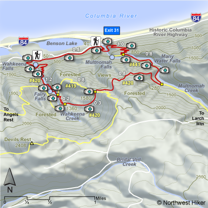
This hike can be done clockwise or counterclockwise. This description
will be clockwise. The paved trail takes the hiker across the bridge between the
lower and upper Multnomah Falls, then continues steeply through mostly wooded
areas with occasional views and many switchbacks to the top of the
ridge.
The trail continues downhill for a short distance then after the
turnoff to the view point at the top of Multnomah Falls, the trail becomes
unpaved. There is a large stone bridge across Multnomah Creek, then the
trail begins to climb again but not as steep. After crossing the bridge
there is a junction to the right to the Perdition Trail which has been closed
for several years due to unsafe conditions.
Continue up Trail #441 pass many outstanding waterfalls for about
.8 miles and turn right at the junction to Trail #420. This trail continues
uphill for another .8 miles then intersects an optional way down to Wahkeena Falls
by Trail #419. Or one can continue on Trail #420 which takes the hiker past
the trail to Angel's Rest and continues downhill past Fairy Falls to Wahkeena Falls.
There is a short half mile hike back to Multnomah Falls that parallels the Old
Columbia River Highway.
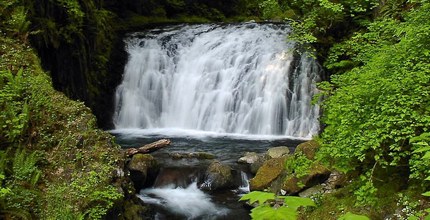 Dutchman Falls on Multnomah Creek as seen from the loop trail.
|
|
How to get there:
From I-84 take Exit #31/Multnomah Falls. Park in the parking lot and walk under
the footbridge to Multnomah Falls Lodge.
Alternatively, take I-84 east to Exit #28/Bridal Veil and drive east on the
Historic Columbia River Highway to the Multnomah Falls Lodge parking area.
Coming from the east on I-84, take exit 35 (Ainsworth Park) and drive about 4 miles west on the
Historic Highway to reach the Multnomah Falls Lodge parking area and trailhead.
From Portland, due to overcrowding at Multnomah Falls in peak season, we highly recommend for convenience and safety, that
you consider using the Gorge Transit bus .
The price is low and the convenience is high.
|