Length: 2.2 miles round trip
Elevation Change: 440' gain
Season: Year Round
Difficulty: Moderate
Permit: Washington State Parks Requires a Permit
GPS: N45 37.9674 W122 1.1838
Latitude: 45.63279
Longitude: -122.01973
Features:
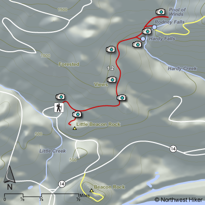
You can begin this hike in either of two trailheads. As you drive
into the park, you will come to the main parking area with restroom
facilities on your right. However, when in season, you can continue
to drive into the campground area and park in another area as seen
on the above map.
An outstanding hike with all the right features such as water falls,
steep cliffy areas, superb views, ridge line hiking, and deep
forested areas, complete with a loop for minimal repeat
scenery.
When Beacon Rock State Park is open, you drive to the
picnic area and park at the Hamilton Mountain trail head. When the
park is closed, leave your car along side the road by Beacon Rock.
The hike begins moderately steep for about a mile then becomes more gentle as
you approach the first of two falls.
Hardy Falls is visible by taking
a short side trip, but Rodney Falls is fully visible as your cross
Hardy Creek on a bridge right at the foot of the falls.
Pool of Winds is a short walk above Rodney Falls and well worth the
extra effort.
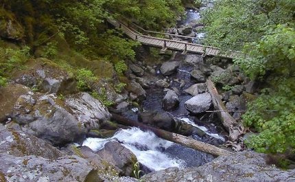 Looking down at the bridge below Rodney Falls
|
|
How to get there:
Beacon Rock State Park: Cross Bridge of the Gods in Cascade Locks ($2 toll). Turn left/west
onto WA Hwy 14. Drive 6.5 miles west to the trailhead on the left side of the road. You'll
see Beacon Rock getting bigger as you approach. As you come to the rest area facilities on
your left, to your right there is a road that you will need to take to the parking area and
trailhead for this hike. A Washington Discover Pass is required here.
Alternatively, drive east on Highway 14. The trailhead is just west of milepost 35. Just before
you come to the rest area facilities at the base of Beacon Rock, you will see a road off to your
left. Follow this road to the parking area and trailhead for this hike. A Washington Discover
Pass is required here.
|