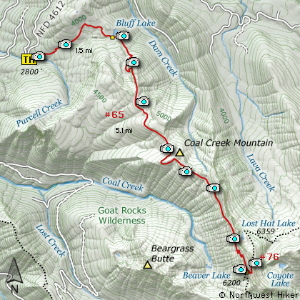
Length: 13.2 Miles round trip
Elevation Change: 3600' Elevation gain / 200' loss
Season: Mid-Summer thru Fall
Difficulty: Difficult
Permit: NW Forest Pass Required
Features:
This hike begins off Forest Road #4612 and begins climbing immediately
to Bluff Lake. The trail is almost entirely in dense forest, and the
lake offers a fine rest point as you prepare for the serious climbing
ahead.
After leaving the lake, the trail begins a very steep and switch backed
climb up Coal Creek Mountain ridge. At this point you get an
occasional view of Mt Rainier to the northwest, but for the most part
the trail is in dense forest.
At about 3 miles the trail begins to level off a bit. The timber is
much larger in this stretch of the trail, but within another mile it
finally enters more open areas. Now the vistas become more common
and are the reward for the long and tough climb.
As the trail closes in on the peak where Coal Creek Mtn lookout used
to stand, you can stray just a bit off the trail to the east and look
down on the valley below including a small lake. The summer I took
this hike, the area around the peak had been through a forest fire
and many of the trees were just blackened objects presenting a rather
surreal environment.
At about 6 miles you will reach a junction of the trail to Lost Lake
which is several hundred feet in elevation below you. If you bear to
the left and continue uphill you will quickly reach the summit and
the excellent vistas that make this hike so worth it!
This is a long hike, but the rewards are tremendous. Give it a try.

Mt Rainier from the Coal Creek Mountain trail
|