Length: 10 Miles round trip
Elevation Change: 1400' Elevation
Season: Mid-Summer thru Fall
Difficulty: Challenging
Permit: NW Forest Pass Required
Features:
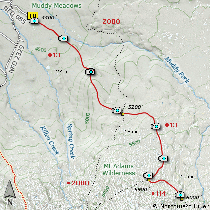
This hike begins off Forest Road #2329-083,
which is just off FR #2329. The trail begins
in a large parking area at Muddy Meadows.
The trail is heavily used by horses but
motorized vehicles are prohibited.
In season this hike is very floral. And
in season it can be very muddy... thus
the name. Oh, before I forget, in season
you can be considered dinner by the local
wildlife.... MOSQUITOS!!!
Now, back to the hike. The trail climbs
gently across Muddy Meadows and at about
a mile it begins to show evidence of a
little more steepness. The hike never
gets really steep, but always gains
elevation on its way to Foggy Flats.
Much of the first 3 miles of the
hike is in heavily forested areas.
At about 2.7 miles the trail crosses
the Pacific Crest Trail #2000. After
that junction the trail becomes less
used, but never hard to follow. The
wildflowers become more common as the
trail enters more open areas. You
will hike beside a sizeable creek along
this part of the trail.
At 4 miles the trail connects with
High Line Trail #114. Take the left
option and follow Trail #114 to open
flat areas referred to as Foggy Flats.
The day I hiked this trail it was very
foggy at Foggy Flats. However, the
clouds did part for just a moment
allowing me an opportunity to get a
few great shots of Mt Adams which are
included in this program.
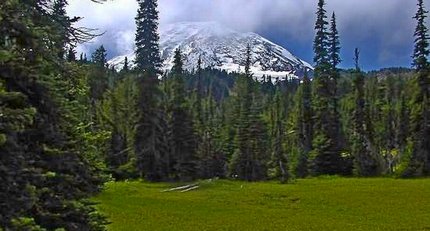
Mt Adams as seen from Foggy Flats
|
How to get there:
NEW!
Click for PDF Directions Map of this Hike
From Portland, OR
From Portland, travel east on Interstate Hwy 84 to Exit 64 at Hood River.
Turn left, and pass under the freeway and cross the toll bridge ($2.00)
into Washington state. Turn left onto SR14 and drive approximately 1.5
miles to state road 141 Alt. Turn right onto SR141 Alt. and follow it another
2 miles and merge bearing left onto SR141. Then travel north on SR141
for another 19 miles to Trout Lake and the junction to Mt. Adams Road. Bear
right and forward onto Mt. Adams Road for about 1.3 miles and you
come to the junction with Forest Road 23. Bear left and ahead
onto FR23 and continue north for about 19 miles and you will come
to the junction with Forest Road 90. Take a sharp right uphill turn
and continue on FR23. At this point the road becomes very rough
surface and you will follow this road for just under 3 miles. You
then come to the junction of Forest Road 2334. Bear right and continue
on FR23 for another 1.4 miles. You will then come to the junction
with Forest Road 2329. Bear right and straight ahead onto FR2329.
FR2329 is paved for the next mile, but don't get used to it. It
turns to gravel again for the remainder of the journey. After leaving
FR23 you will travel about 5.8 miles and come to the trailhead for
Killen Creek on your right. But for this hike, you continue another
1.7 miles to the road on your right that takes you to Muddy Meadows,
which is where the trailhead for Foggy Flats is located.
|