

|
THE FOLLOWING MAP IS NOT TO BE USED FOR NAVIGATIONAL PURPOSES.
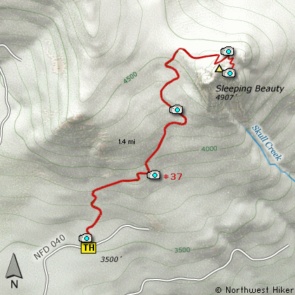
Map of the Sleeping Beauty Mountain Hike
|
Length: 2.8 Miles round trip
Elevation Change: 1400' Elevation gain
Season: Summer thru Fall
Difficulty: Difficult
Permit: No Pass Requirement
Features:
Talk about bang for your buck, this
little hike is a real gem tucked away
in a mostly logged area. The trail
begins off Forest Road #040, which is
just a short ways off FR #88.
This trail begins climbing very
steeply right at the beginning and
doesn't actually let up until you
reach the ridge line next to the
summit. The entire hike is within
dense forest, and that shouldn't
matter as you will be too busy
trying to breathe, so you wont
notice the lack of scenery.
At about a mile you will level out
on the ridge and after you get your
heart rate in control, you can
follow the trail up the extremely
steep north side of the peak.
In places the trail has been carved
into the mountain to make it possible
to reach the top without technical
gear.
Oh, but when you reach the top, what
a reward. After you wipe the sweat
from your eyes they will drink in
more beauty than they can hold. You
will be able to see all the local
Cascade Volcanos, including Mt Rainier
to the north, Mt Adams just a short
distance away to the northeast, Mt
Hood to the south in Oregon, and of
course good ol Mt St Helens to your
west.
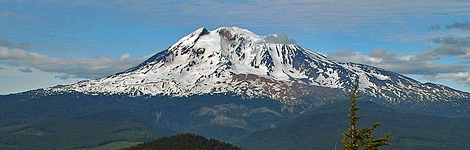
Mt Adams as seen from Sleeping Beauty
|
How to get there:
NEW!
Click for PDF Directions Map of this Hike
From Portland, OR
From Portland, travel east on Interstate Hwy 84 to Exit 64 at Hood River.
Turn left, and pass under the freeway and cross the toll bridge ($2.00)
into Washington state. Turn left onto SR14 and drive approximately 1.5
miles to state road 141 Alt. Turn right onto SR141 Alt. and follow it another
2 miles and merge bearing left onto SR141. Then travel north on SR141
for another 19 miles to Trout Lake and the junction to Mt. Adams Road,
which heads north to other hike destinations.
from Trout Lake, WA
Bear left and continue on SR141 for another 1.7 miles where you will
come to Trout Creek Road, which is also Forest Road 88 on your right.
Turn right onto FR88 and follow it north-northwest for about 3.9 miles
and you will come to Forest Road 010, but stay on FR88 for another
.7 mile, and turn right onto Forest Road 8810.
Follow FR8810 for a little over a mile and you will come, once again, to
Forest Road 010. The reason for taking FR8810 rather than FR010 when you
first passed it, is that FR8810 has typically been in better condition.
At the junction of FR8810 and FR010, turn left and follow FR10 up a series
of steep switchbacks for another 4.9 miles and you will come to Forest Road 040.
Turn right onto FR040 and follow it for about a quarter mile to the trailhead for this hike.
The trail begins on the left side of the road, and you'll need to park on the right
shoulder.
|
|
|
A Virtual Hike in the Gifford Pinchot National Forest


|
|


