

|
THE FOLLOWING MAP IS NOT TO BE USED FOR NAVIGATIONAL PURPOSES.
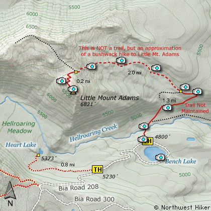
Map of the Little Mt Adams Hike
|
Length: 7 Mile Round Trip
Elevation Change: 2200' Elevation Cumulative gain
Season: Mid-Summer thru Fall
Difficulty: Difficult
Permit: Yakima Nation Pass Required
Features:
PLEASE NOTE:
This is an unmaintained trail with
scrambles.... much of the way with no trail at all.
DO NOT ATTEMPT THIS HIKE UNLESS YOU ARE ENTIRELY
EQUIPPED AND EXPERIENCED FOR SUCH AN ADVENTURE.
ALSO:
You cannot access this area without the permission of the
Yakima Nation.
Here is another fantastic gem located with the Yakima
Indian Reservation. Remember, a pass is required and
can be purchased along the road to Bench Lake.
At about 1/4 mile the trail drops steeply and crosses
Hellroaring Creek on a newly constructed bridge. The
trail begins to climb, but junctions shortly after the
bridge. Bear left and begin the steep climb to the
crest of the ridge.
At about 1.3 miles the trail passes a clearly visible
trail marker and it is at this point that I recommend
a cross-country scramble following the ridge line above
you.
Little Mt Adams is in sight almost all the time, so
it is not difficult to scramble your way below the
ridge you are following to the base of the mountain.
When you reach the base on the north side you will
see a trail that others have used to reach the summit.
Be sure to drop down into the crater itself and look
around for great vistas of Bench Lake, Heart Lake,
and of course Hellroaring Canyon and the gorgeous
Mt Adams which looms over you.
A challenging return option is to descend into
Hellroaring canyon to the west of Little Mt Adams,
and cross the swampy meadows to Heart Lake. Finding
Heart Lake is a bit of a challenge, but just
remember, to keep from getting lost, there is an
excellent trail along the south side of Hellroaring
Meadow, so if you can't find the lake, just walk
south across the meadow until to intersect the
trail that you can follow east back to the road which
you took to Bench Lake.
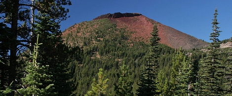
Little Mount Adams
|
How to get there:
NEW!
Click for PDF Directions Map of this Hike
From Portland, OR
From Portland, travel east on Interstate Hwy 84 to Exit 64 at Hood River.
Turn left, and pass under the freeway and cross the toll bridge ($2.00)
into Washington state. Turn left onto SR14 and drive approximately 1.5
miles to state road 141 Alt. Turn right onto SR141 Alt. and follow it another
2 miles and merge bearing left onto SR141. Then travel north on SR141
for another 19 miles to Trout Lake and the junction to Mt. Adams Road,
which heads north to other hike destinations.
from Trout Lake, WA
Bear right and forward onto Mt. Adams Road for about 1.3 miles and you
come to the junction with Forest Road 23.
Bear right and continue on Mt. Adams Road, which is also Forest Road 82,
for another half mile or so, and when you come to Forest Road 80, bear again
to the right and stay on FR82. To reach the Bird Creek Meadows area, just
stay on FR82 for another 8.3 miles past FR80. At this point, FR82 turns
into the Bureau of Indian Affairs Road 285 as well as FR8290.
Continue on BIA285 for another 4.2 miles and you will come to Mirror Lake
and the junction of BIA304 which takes you to Bird Lake. Continue another
mile and you will pass the parking area and trailhead for Bird Creek Meadows
on your left. BIA 208 now becomes extremely challenging, and heads down
a steep rough grade for about a mile and a half to the entrance of the
Bench Lake camping area. The road may be a one-way drive, so bear to your
right and drive around the lake to the obvious trailhead parking area on
the north side of the lake. As you drive around the lake, be sure to stop
for a moment and walk down to the lake and enjoy the incredible view of
Mt. Adams and Little Mt. Adams as seen from the lake.
|
|
|
A Virtual Hike in the Gifford Pinchot National Forest


|
|


