

|
THE FOLLOWING MAP IS NOT TO BE USED FOR NAVIGATIONAL PURPOSES.
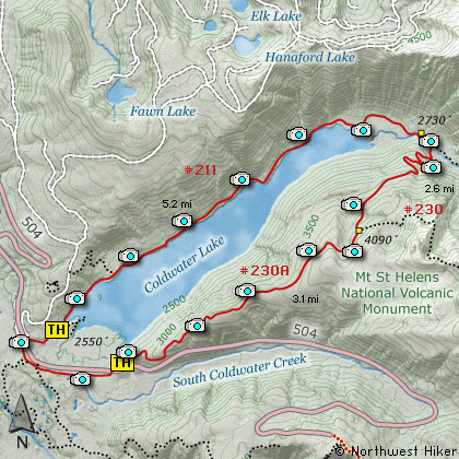
Map of the Mt St Helens, Coldwater Lake Loop Hike
|
Length: 12.2 Miles round trip
Elevation Change: 1600' Elevation gain
Season: Summer thru Late Fall
Difficulty: Challenging
Permit: NW Forest Pass Required - Check with the local Forest Service to
determine any other pass requirements
Volcano Alert
Call this number to see if this trail is closed:
360-449-7800
Features:
This hike may seem attractive, but please
keep in mind that this is a long hike, and
parts of this trail are in very poor repair.
Having said that, welcome to a wonderul and
exciting hike option in the Mt St Helens NVM
area. I encourage you to make a loop out of
this hike by beginning anywhere along the
paved access road that skirts Coldwater Lake
to the south. There are a number of parking
areas to choose from to begin your hike
around Coldwater Lake. Be sure to give
yourself plenty of time, and take lots of water.
I parked at the Hummocks parking area and
headed east, walking the shoulder of the
road to the trailhead indicated on the map.
The trail then begins a steady and reasonable
climb up the ridge along the east side of
Coldwater Lake. Because Mt St Helens blew
all the trees down, you will be out in the
open most of the hike and the views are
simply spectacular.
As you climb the ridgeline you will catch
occassional views of Mt St Helens and the
surrounding peaks. In season, this is a
very floral hike. In the fall you have a
great likelihood of view elk.
About a couple miles into the hike you
will come across machinery that was blown
about by the catastrophic explosion of
Mt St Helens. Around three miles into the
hike you will come to a junction that connects
with a trail from the Coldwater Peak area.
However, for this hike, you bear to the left
and begin you descent into the Coldwater
Creek drainage. The trail is very poorly
maintained along this part, but at last
report the Forest Service was working on it.
As you descend into the canyon you will have
incredible views of Minnie Peak and even
Mt Whittier to the northeast of you. There
are places where you can see Coldwater Peak
also.
When ou switchback your way to the bottom
of this canyon there is a sturdy and rather
spectacular bridge waiting for you to cross
to the north side of Coldwater Creek. Once
across the creek, follow the trail to your
left, towards Coldwater Lake and the road
where you left your vehicle.
Taking the trail to the right will lead you
deep into the Mt Margaret Backcountry and a
long long long ways from your car.
The trail now wanders along the northwestern
and western shoreline of Coldwater Lake all
the way back to the trailhead near the place
where you began this trek. The trail is not
level, but is very easy to follow and offers
simply fabulous views of the lake and the
surrounding peaks.
In the fall the lake shore is full of
brilliant colors.
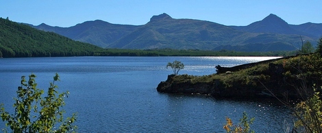
A view of Coldwater Lake from the Loop Trail
|
How to get there:
NEW!
Click for PDF Directions Map of this Hike
From Seattle, WA
Drive south on I-5 to the junction of State Road 504. Exit the freeway, and turn
left (east) onto SR504 and follow it east, past the Silver Lake Visitor Center and
on to the Coldwater Lake Visitor Center. (closed) Take the exit directing you to
Johnston Ridge, but as you descend toward Coldwater Creek, you will come to a parking
area on your right. Park here and walk eastward along the paved road to the
trailhead for the South Coldwater trail, which will be on your left.
From Portland, OR
Drive north on I-5 to the junction of Washington State Road 504. Exit the freeway, and turn
right (east) onto SR504 and follow it east, past the Silver Lake Visitor Center and
on to the Coldwater Lake Visitor Center. (closed) Take the exit directing you to
Johnston Ridge, but as you descend toward Coldwater Creek, you will come to a parking
area on your right. Park here and walk eastward along the paved road to the
trailhead for the South Coldwater trail, which will be on your left.
|
|
|
A Virtual Hike in the Mt. St. Helens National Volcanic Monument


|
|


