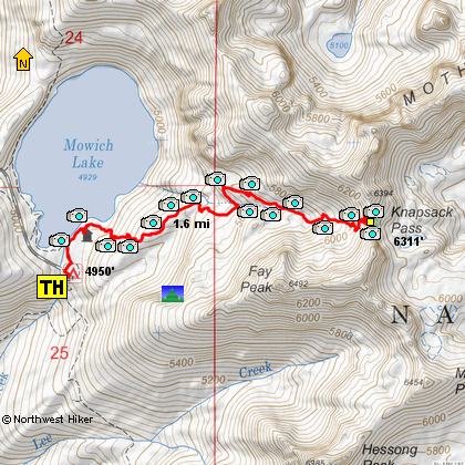
Length: 3.6 mile RT
Elevation Change: 1323' cumulative elevation gain
Season: Summer thru Fall
Difficulty: Challenging
Permit: park entrance fee
Features:
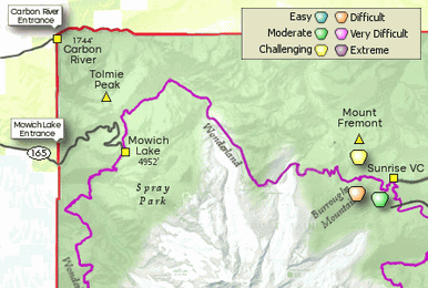
The trailhead for this hike is Mowich Lake Campground.
Head toward the lake, then take a right along the shore.
It's a short distance to the old ranger cabin at the
southeast corner of Mowich Lake. The trail begins up
and to the left of the cabin. For the best experience,
start your hike early in the day as Mount Rainier
often clouds up around noon time. The mountain is
usually best seen before noon or late in day.
The trail to Knapsack Pass is unmaintained but
well-established. It’s not the typical park trail
and will be rough in spots. If you are an experienced
hiker with a sense of adventure, this short, steep
out-and-back hike is for you and will reward you
with breathtaking views.
The trail rises steeply though the woods at first,
but then breaks out into open country. The trail
passes several small waterfalls surrounded by
lush patches of wildflowers. There is a little
trail finding required to pick up the trail at
the top of a small meadow.
Then the trail rises up a spectacular bowl surrounded
by towering rock formations. In season, there are
abundant wildflowers. Fay Peak is on the right and
Mother Mountain is on the left. Follow the switchbacks
to the top of Knapsack Pass and its fantastic view
of Mt. Rainier.
Hiking beyond Knapsack Pass is undertaken at your own risk,
though a distant visible trail will tempt you. The terrain
beyond the pass is difficult, unmarked and requires
crossing a large rock field with high potential for injury.
Its possible that the Knapsack Pass trail is no longer
maintained to keep hikers off the boulder field and the
fragile tundra beyond.
An added benefit to this hike is Mowich Campground. The campground
requires no reservations, but the number of campsites is limited.
The restrooms are well maintained. Bear safety rules must be
followed and there is a locker for food and toiletries. Park
rangers have a small headquarters nearby, so they are often
around for advice and assistance. The only downside is the
lack of privacy. This campground
is more functional than it is scenic; it is often used for
support crews who assist others hiking the entire Wonderland
Trail around Mount Rainier.
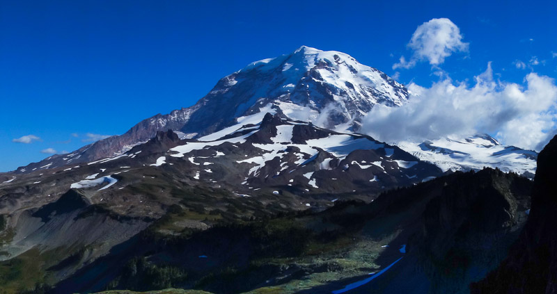
Knapsack Pass panorama
|