|
THE FOLLOWING MAP IS NOT TO BE USED FOR NAVIGATIONAL PURPOSES.
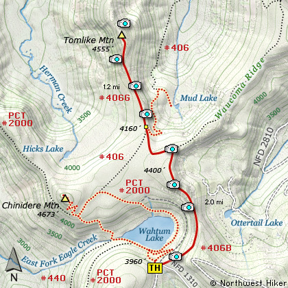
Map of the Tomlike Mountain Hike
|
Length: 6.4 miles round trip
Elevation Change: 500' climb then 300' drop then 400' climb
Season: Early Summer thru Late Fall
Difficulty: Moderate
Permit: NW Forest Pass Required
GPS: N45 34.638 W121 47.574
Latitude: 45.5773
Longitude: -121.7929
Features:
NEW!
Click for PDF Topo Map of this Hike
This is one of many hikes in the Wahtum Lake area. The trail begins
right behind the outhouse at the parking area for Wahtum Lake. You climb a steady
moderate climb to the top of a ridge that provides you will excellent views of the
surrounding peaks and valleys. You will cross an old unused road that used to service
Wahtum Lake and fire lookouts on the nearby hilltops.
At about two miles you will be on the edge of a ridge that runs north to Tom Like Mountain.
The trail out to Tom Like Mtn is feeble at best, but because most of the hike is out in the
open, you really don't need a trail. Just aim at the mountain (highest point ahead of you).
The one challenge is finding your way through a grove of scrub pine. Someone has cut a good
path through the trees and you shouldn't have too much trouble finding it.
From the top of Tom Like Mtn you get a 360 degree view.... all beautiful. Mud Lake is below
you and to the southeast; Mt Hood to the south, Tanner Butte to the west, Mt St Helens to the
northwest; Mt Rainier to the north; Mt Adams to the northeast; Mt Tom to the east.

Mt. Rainier and Mt. Adams as seen from
the Tomlike Mountain Trail
|
How to get there:
These directions take you from Hood River, Oregon.
Whatever direction from which you arrive at Hood River,
follow the sign of old US Hwy 30 into town. From the
west turn right on 13th Street and follow it up the
hill until it merges with 12th. If you are approaching
from the east, on US 30, turn left on 9th and follow it
up the hill until it merges with 12th. Either way,
follow 12th south out of town on what is called
Tucker Road or Hwy 281. About 6 miles out of town you
will cross the Hood River. Immediately after the bridge,
bear right and pass Tucker Park. In about another
six miles you need to bear to the right again following
signs to Lost Lake. This community is referred to as Dee.
As soon as you cross the railroad tracks, bear left and follow the signs to
Lost Lake. This paved road becomes Forest Road 18, and
you need to follow it about another 5 miles. Then
bear right on Forest Road 13 for another 4 miles. Again,
bear right on Forest Road 1310 Forest Road 1310 get a bit narrow in
places, especially where it is exposed to the south.
Be extremely cautious while driving this section of
the road and stay away from the cliff side.
Continue on FR1310 for about another 6 miles to the trailhead parking area
at Wahtum Lake. This is the trailhead for several hikes.
|
|
|
A Virtual Hike of the Mount Hood National Forest


|
|