

|
THE FOLLOWING MAP IS NOT TO BE USED FOR NAVIGATIONAL PURPOSES.
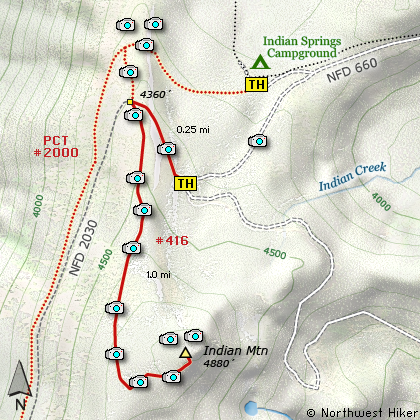
Map of the Chinidere Mountain Hike
|
Length: 2.5 miles round trip from Campground
Elevation Change: 580' gain
Season: Late Spring thru Fall
Difficulty: Moderate
Permit: NW Forest Pass Required
Features:
NEW!
Click for PDF Topo Map of this Hike
This spectacular little hike can begin at the Indian Springs Campground
of it can begin at the Wahtum Lake trail head. A primitive road allows the visitor
to drive much closer to the mountain, and take several miles off the hike.
There are a couple of choices as to where to begin the hike even if you choose to
start at the campground. The Pacific Crest Trail #2000 passes through the very
unmaintained camp area and you can find the trail head there. Or you can drive a bit
further and park along the road where a barricade blocks you from driving further and
hike from there.
The trail follows the old service road used to access the fire lookout that once stood
atop Indian Mountain. So, it is very easy to follow even if it is not well maintained.
The short hike up this mountain is so worth the excellent views you can enjoy not only
at the top but most of the way to the top. Only the last little bit of the trail is
in dense forest.

Mt. St. Helens, Mt. Rainier, and Mt. Adams as
seen from the Indian Mountain Trail
|
How to get there:
NEW!
Click for PDF Directions Map of this Hike
These directions take you from Hood River, Oregon.
Whatever direction from which you arrive at Hood River,
follow the sign of old US Hwy 30 into town. From the
west turn right on 13th Street and follow it up the
hill until it merges with 12th. If you are approaching
from the east, on US 30, turn left on 9th and follow it
up the hill until it merges with 12th. Either way,
follow 12th south out of town on what is called
Tucker Road or Hwy 281. About 6 miles out of town you
will cross the Hood River. Immediately after the bridge,
bear right and pass Tucker Park. In about another
six miles you need to bear to the right again following
signs to Lost Lake. This community is referred to as Dee.
As soon as you cross the railroad tracks, bear left and follow the signs to
Lost Lake. This paved road becomes Forest Road 18, and
you need to follow it about another 5 miles. Then
bear right on Forest Road 13 for another 4 miles. Again,
bear right on Forest Road 1310 Forest Road 1310 get a bit narrow in
places, especially where it is exposed to the south.
Be extremely cautious while driving this section of
the road and stay away from the cliff side.
Continue on FR1310 for about another 6 miles to the trailhead parking area
at Wahtum Lake.
At this point, turn left and follow the graveled FR660
up the hill away from Wahtum Lake. For the next
couple miles, always bear right at junctions. You will
follow this poorly maintained road down a steep hill
and across a saddle then back up to a ridge line. Almost
unnoticed, you will see a poorly maintained road drop
off to the right and down a steep slope. Do not take
this road to the campground.
If however, you choose to not begin your hike on the PCT,
don't drop off FR660, but continue on until
you come to a split in the road. Bear right and park
in front of the barricade, as you will be walking up
this abandoned road to Indian Mountain.
|
|
|
A Virtual Hike of the Mount Hood National Forest


|
|


