

|
THE FOLLOWING MAP IS NOT TO BE USED FOR NAVIGATIONAL PURPOSES.
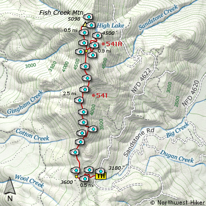
Map of the Fish Creek Mountain and High Lake Hike
|
Length: 8.2 mi RT
Elevation Change: 2572' gain
Season: Summer thru Fall
Difficulty: Difficult
Permit: NW Forest Pass Not Required
Features:
NEW!
Click for PDF Topo Map of this Hike
This is a hike that lost access to it by a significant road washout several years ago. But
thanks to the hard work of several volunteers and old trail had been reclaimed, thus providing
a way for us to enjoy this extraordinary hike.
Actually, the new approach isn't bad at all. And the road that brings you to the new trailhead
was actually washed out, probably by the same event, just a short distance from where you need
to park in order to use the newly reclaimed old trail, which leads up to the original Fish Creek
Mountain trail. Well, it leads up to the road that used to take you to the Fish Creek Mountain trail.
When you arrive at this unmarked trailhead, exactly 7.8 miles from the Indian Henry Bridge over
the Clackamas River, you can park anywhere off FR 4622, and there is plenty of room. Just park
in front of the barricade put in place to close FR 4620. This point is actually the old junction
of FR 4620 and FR 4622. FR 4622 does continue, but you need to park here.
This very rugged connector trail climbs very steeply up the side of Fish Mountain Ridge. In
almost any situation the trail is slippery and can be more difficult to come back down that
go up. Nevertheless, it is only about a half mile climb to the top, where you walk through
a very young dense forest briefly before walking out onto the old road that used to take folks
to the trailhead. They have now filled in the old road, so the trail walks on top of the fill.
In about another half mile you come to a noticeable wide spot in the filled road, with a trail
running up a ridge in front of you into the forest. This is the trail. Actually, after just
a few feet of climbing up this very steep embankment, you will see the trail sign on a tree in
front of you. Now begins the real hike... the hike you came for.
The hike from here on is a continual steady climb along Fish Creek Mountain ridge, with occasional
opportunities to view out over the surrounding hillsides and even from time to time views of
Mt. Jefferson to the southeast, and an occasional glimpse of Mt. Hood. In season the climb is
made delightful by numerous wildflowers, especially the ever present Rhododendrons. They are
simply gorgeous when in full bloom... usually the middle of July.
About three miles into this hike you will come to the junction of the trail to High Lake. The
trail to High Lake was not marked when we hiked it, but it is obvious that you are there. Actually,
there is a sign on the Fish Creek Mountain trail telling you that you are a half mile from the
summit, but no sign referring to High Lake. We did Fish Creek Mtn. first, then came back and
dropped down to High Lake.
As you continue on your way to the summit of Fish Creek Mountain, the trail follows on the very edge
of the ridge line. It drops off steeply on both sides of you, which makes a fun trail... not dangerous,
but fun. Just before you reach the very summit of Fish Creek Mountain, the trail skirts to the left
and up around a rocky area. It is this rocky area that will be the most rewarding part of your hike.
There were a couple of pink ribbons on a small tree right in front of this rocky area, indicating
the place to scramble up to the top. There you will be treated to the views for which you hiked this
hike. When you continue on to the actual summit of Fish Creek Mountain, you will have almost no views
of Mt Hood. But you do get great views of Mt. Jefferson to the southeast.
However, on top of the rocky bluff you get great views in all directions. And, to me, the greatest
treasure we found on top of this off trail location was the Geological Survey Marker, dated 1913!
Now this was a treasure.
After resting and refreshing, I recommend you head down to High Lake. Just walk back to that junction
which I described earlier, and follow the trail down to the lake. High Lake is a beautiful little lake,
nestled along the eastern flank of Fish Creek Mountain. You can easily walk completely around the lake
and enjoy it from all angles. From the eastern side, you can see Mt. Hood through openings in the
forest which inhabits the eastern shore, and on the mountain side of the lake is a large barren rock fall.
Obviously, be careful crossing this so you don't have to limp back to your vehicle.
One more thing. The roads in the central Mt. Hood National Forest are logging roads. So, don't be surprised
if you have to deal with logging trucks and/or road closures due to logging. Contact the Forest Service at
Ripplebrook or Estacada to learn if your road of choice is open.

High Lake at the base of Fish Creek Mountain
|
How to get there:
NEW!
Click for PDF Directions Map of this Hike
To reach this trailhead, just head south out of Estacada until you come to the bridge
over the Clackamas River at the junction of Forest Road 4620 and Hwy 224. This is the
same junction for Indian Henry Campground. Follow FR 4620 past Indian Henry campground
until you are 7.8 miles from the intersection at the bridge. Here you will see that the
road used to make a sharp left turn but is now barricaded, as it is washed out a short
way past this.
You can park right in front of the barricade, and the connector trail you need, which
will take you up the ridge to the Fish Creek Mountain trail is on the north side of this
parking area. The trail is kinda hard to see, but you should have no problem locating
it. This point is a junction for the old barricaded FR 4620 and FR 4622, which continues
on north from here. Be sure not to block that road.
|
|
|
A Virtual Hike of the Mount Hood National Forest


|
|


