

|
THE FOLLOWING MAP IS NOT TO BE USED FOR NAVIGATIONAL PURPOSES.
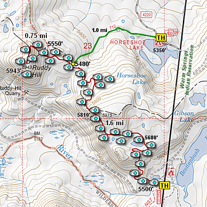
Map of the Ruddy Hill Hike
|
Length: 5 mi RT
Elevation Change: 900' cumulative change
Season: Summer thru Fall
Difficulty: Moderate
Permit: NW Forest Pass NOT Required
Features:
NEW!
Click for PDF Topo Map of this Hike
Here is another wonderful hike located within the south Olallie Lake Basin.
I began the hike at the PCT Trail head located near the Breitenbush Trailhead
parking lot.
I choose to present this second approach to Ruddy Hill because of the incredible
vistas you get to experience along this portion of the Pacific Crest Trai. You
begin this hike on the PCT where it crosses FR 4220, and head north in a gentle
climb. Unfortunately, there was a forest fire here a couple of hears ago, so for
the first half mile, you will walk through a burnt forest
On the bright side, with the trees all burned up, you get excellent views of Mt.
Jefferson rising higher and higer in view as you gain elevation on this portion
of the trail.
After about a half mile you will come to a beautiful little lake nestled just off
the west side of the PCT. Walk over to the edge of this lovely lake and enjoy the
view of Mt. Jefferson looming to the south.
After leaving this lake you will soon come to another pond just a short distance away.
This is a beautiful little lake and offers fine views of the ridges to the north.
After continuing on your way north on the PCT you will soon catch a glimpse of your
destination; Ruddy Hill. You cannot mistake it, as it is the only red mountain in
sight. At this point the PCT continues to climb as it makes its way along a steep
treeless slope which offers you extraordinary views of Mt. Jefferson to the south.
Soon the trail enters a forest, which very quickly turns into another burnt forest before
it turns back into a beautiful lust green forest. The trail begins a steep desent into a
saddle where you will pass the trail to Gibson Lake, and just a bit further the trail to
Horseshoe Lake. The trail from Horseshoe Lake is an optional way to reach Ruddy Hill,
but it will miss the beautiful lakes along the PCT approach from Breitenbush TH.
After passing the trail to Horseshoe Lake, it is only a quarter of a mile of less to
the trial that takes you up Ruddy Hill. As you walk north on the PCT, the trail up
Ruddy Hill is on your left and marked with a sign attached to a tree.
The short half mile climb up Ruddy Hill is actually very steep. Some may think it is
extremely steep, so just take your time and continue to climb as the reward at the top
is so worth it.
From the summit of Ruddy Hill you have fantastic views of Mt. Jefferson rising up behind
Park Ridge. Pyramid Butte is just across the canyon and doesn't look all that high from
this vantage point.
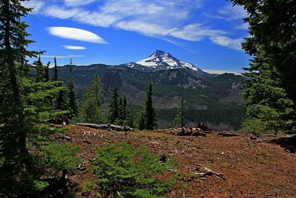
View of Mt. Jefferson from Ruddy Hill
|
How to get there:
From Estacada, OR take OR-224 E/Clackamas Hwy southeast for 25.3 miles.
Then go right onto Forest Service Road 46 (This road may be seasonally closed)
and follow for 28 miles. Then turn left onto Forest Service Road 4220
and follow for about 7 miles to the Breitenbush Trailhead parking area.
Note that the last 7 miles of this approach is extremely primative road.
|
|
|
A Virtual Hike of the Mount Hood National Forest


|
|


