

|
THE FOLLOWING MAP IS NOT TO BE USED FOR NAVIGATIONAL PURPOSES.
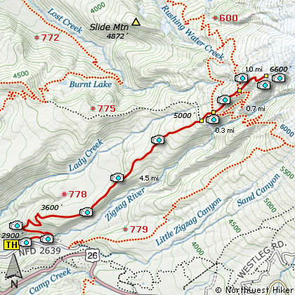
Map of the Zig Zag Canyon Ridge, Paradise Park Hike
|
Length: 13 miles round trip
Elevation Change: 3700' gain
Season: Early Spring thru Late Fall
Difficulty: Difficult
Permit: NW Forest Pass Required
Features:
NEW!
Click for PDF Topo Map of this Hike
There are several trails that lead to Paradise Park on the western slope
of Mt Hood. This particular hike travels what is known as the Paradise Park Trail.
This is a long and steep hike. The hike is rather level for the first half mile
before you begin to ascend climb along the side of a steep hillside within a dense forest.
In the first five (5) miles there are only a couple places where you have a view of the
surrounding hills and valleys. At 4.5 miles you intersect Trail #775 to Burnt Lake. Then
about a half mile later you intersect the Pacific Crest Trail #2000 and Timberline Trail #600.
Cross this trail and continue uphill for another half mile and you will come to Trail #757
which is a loop trail for Paradise Park.
Cross this trail also and continue uphill toward
Mt Hood. By now you are hiking in open meadows which in season are full of wildflowers.
The trail gets very steep now and become difficult to follow as you reach a viewpoint at
about 6600' in elevation. You are standing in front of Mississippi Head with Mt Hood looming
behind. Below you are panoramic views reaching from Mt Jefferson to the south and Mt St Helens
to the northwest.
One advantage to reaching Paradise Park via this route is if you choose to hike early in
the summer you will be less exposed to left-over winter snows. Starting at 2900', you don't usually find snow until the 5000' level
and just a short walk to Paradise Park. However, if you begin at Timberline Lodge, you are
already at 6000' and will walk on snow almost the entire distance.

The trail up Zig Zag Canyon Ridge to Paradise Park
|
How to get there:
NEW!
Click for PDF Directions Map of this Hike
Follow US 26 about 4 miles east of Rhododendron
to Road 2639, marked by a sign indicating the
Kiwanis Camp. Turn left onto this paved road
and follow it for about a mile. Turn left on
Forest Road 021 which crosses a wooden
bridge and brings you to a designated campground.
The trailhead is on your left in the middle of
this camp area.
|
|
|
A Virtual Hike of the Mount Hood National Forest


|
|


