

|
THE FOLLOWING MAP IS NOT TO BE USED FOR NAVIGATIONAL PURPOSES.
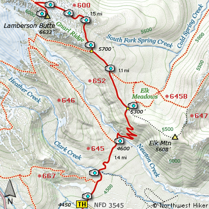
Map of the Gnarl Ridge, Lamberson Butte Hike
|
Length: 8 miles round trip
Elevation Change: 2033' gain
Season: Early Summer thru Fall
Difficulty: Challenging
Permit: NW Forest Pass Required
GPS: N45 19.554 W121 38.088
Latitude: 45.3259
Longitude: -121.6348
Features:
NEW!
Click for PDF Topo Map of this Hike
The hike up Gnarl Ridge to Lamberson Butte is a real gem. The hike
begins near the Mt Hood Meadows Sno Park area and travels level for nearly the first
mile. The most difficult part of the hike is crossing Newton Creek. The water is
fast and depending on the time of year or current weather conditions, the water can
vary greatly in depth. Use caution crossing. After reaching the north side of the
creek, the trail climbs vigorously for about a half mile through a series of 9 switchbacks.
At the top of the ridge, the trail intersects the trail to Bluegrass Ridge and Gnarl Ridge.
If you continue straight ahead, you will come to Elk Meadows. However, follow Trail #646
on your left up Gnarl Ridge toward Mt Hood.
In a little over a half mile you will pass the intersection of Trail #652A which also leads
to Elk Meadows. Continuing on you will come to the Timberline Trail #600 which will lead
to Lamberson Butte. In about a mile and a half the trail opens up on a ridge at the base
of Lamberson Butte. At that point, one must scramble up the northwest side of the butte to
reach the top. The view is as good as it gets and the cliff off Lamberson Butte down to
Newton Creek is very impressive. Use Caution.

Mt. Hood from the base of Lamberson Butte
|
How to get there:
NEW!
Click for PDF Directions Map of this Hike
Follow Oregon Hwy 35 south of Hood River or
north from Hwy 26 near Government Camp until
you come to Road 3545 just a mile or so
north of the turnoff to the Mt Hood Meadows
Ski Resort. Turn on this short
access road for about a half mile and the
trailhead is on the north side along with
the parking space.
Note: This is the same trailhead for the
Mt. Hood Meadows Loop hike, the Elk Meadows hike,
the Newton Creek Loop hike and the Lamberson Butte/Gnarl
Ridge hike.
|
|
|
A Virtual Hike of the Mount Hood National Forest


|
|


