

|
THE FOLLOWING MAP IS NOT TO BE USED FOR NAVIGATIONAL PURPOSES.
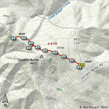
Map of the Gordon Butte Overlook Hike
|
Length: 4 mi RT
Elevation Change: 728' gain
Season: Summer thru Fall
Difficulty: Moderate
Permit: NW Forest Pass Not Required
Features:
NEW!
Click for PDF Topo Map of this Hike
This is an unusual hike in many ways. I call this the Gordon Butte Overlook Hike, but
the trail name is actually the Douglas Cabin Trail. I'm sorry, but I don't know why.
This trail eventually goes all the way to Flag Point which is about 6 miles away. I did
the entire distance when I explored this area and took the images for this hike, but I
would never recommend the hike to all the way to Flag Point to anyone. After the first
couple miles, it becomes obvious that the trail has not been logged out for at least a hundred years.
OK, maybe 50, but you get the point.
However, I include this hike because the first couple miles are logged out and fairly easy to follow.
And after the trail passes over the northern shoulder of Gordon Butte, it takes you out onto an open area with
some really spectacular views; ranging from the Sister's area to the south to Mt. Hood which is northwest
of the viewpoint.
I like this hike because it is on the dry side of the Mt. Hood National Forest, and because of the large
Ponderosa Pine trees that grow along the trail. Whenever the weather is iffy on the west side of the
mountains, it is likely that the 90 mile drive to this hike will give you at the least a dry hike and
at the most spectacular views.
The hike never gets very steep, but near the end of the hike where the viewpoints are located, the
trail does drop suddenly and steeply but only for a few hundred feet. Of course you have to climb
back up that few hundred feet to return to your vehicle, but it is worth it.
And in the late spring, the wild flowers are abundant, adding yet another reason to give this hike a try.

A glimpse of Flag Mountain Lookout
from the Gordon Butte trail
|
How to get there:
NEW!
Click for PDF Directions Map of this Hike
There are a number of ways to reach the trailhead to this hike. I choose to approach the area
from the north, by heading south from Hood River on Hwy 35. Then taking Forest Road 44 east
toward Dufur until I reached the junction with Forest Road 4420, which takes you south toward
Fifteen Mile Camp and Flag Point. However, FR 4420, cuts off to the west, and you need to then
follow Forest Road #2730 which takes you past Fifteen Mile Camp, and past FR 200 to Flag Point,
and east toward Tygh Valley. Up to this point the road is paved, but when you leave the
Mt. Hood National Forest land, the road becomes gravel. It will remain gravel until you come
to the junction with Forest Road 27.
At this point, you will need to make a very sharp right turn, onto FR 27 which will then
lead you to Forest Road 2710. Again, you will need to make a very tight right turn onto
FR 2710, which will take you southeast and about a mile after you cross Little Badger Creek,
you will need to bear right onto Forest Road 2711. Follow FR 2711 only a short distance,
then turn right onto Forest Road 120. Follow FR 120 for about 3/4 of a mile, and the road
will split, bear left. This primitive road will take you in about 2.5 miles to the Gordon Butte
Trailhead, which is actually labeled the Douglas Cabin Trail #470.
|
|
|
A Virtual Hike of the Mount Hood National Forest


|
|


