Hike 52
The Mt. Hood National Forest
Palmateer Point Hike
Search Northern Hikes Mt Hood Hikes Eastside Hikes Central Hikes Southern Hikes
Home Page
Main Map


Click to view product details

THE FOLLOWING MAP IS NOT TO BE USED FOR NAVIGATIONAL PURPOSES.
Map of the Barlow Pass, Palmateer Point Hike

Length: 4.9 miles round trip
Elevation Change: 350' gain
Season: Early Summer thru Fall
Difficulty:   Easy
Permit:   NW Forest Pass Required

Features:

NEW!
 Click for PDF Topo Map of this Hike 

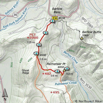
This hike begins at the historic Barlow Pass trail head. The hike begins on the famous Pacific Crest Trail (Trail #2000) and gently climbs for about a mile. After a gentle descent, you come to the junction with Trail #482 which descends further into a meadow area where another junction takes you to the Palmateer Point viewpoint.


Mt. Hood from Palmateer Point
How to get there:

NEW!
 Click for PDF Directions Map of this Hike 

Take Highway 35 south from Hood River or North from Hwy 26 near Government Camp until you reach the Barlow Pass Sno Park. This is the trailhead for a number of hikes in the area.


Hike Difficulty Calculator

Calorie Burn Calculator

The 10 Essentials
Bear Encounters

Cougar Encounters

River Crossing Safety
A Virtual Hike of the Mount Hood National Forest


Click to View Instructions