

|
THE FOLLOWING MAP IS NOT TO BE USED FOR NAVIGATIONAL PURPOSES.
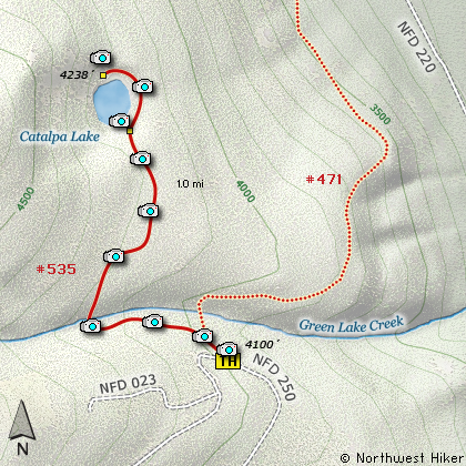
Map of the Catalpa Lake Hike
|
Length: 2 mi RT
Elevation Change: 175' gain
Season: Summer thru Fall
Difficulty: Easy
Permit: NW Forest Pass Not Required
Features:
NEW!
Click for PDF Topo Map of this Hike
This is an outstanding little hike with exceptional rewards. The trailhead is
right off forest road 250 and is well marked. The trail itself is kept in
good condition.
The hike in to Catalpa Lake is gentle and short. The whole family can enjoy this
little gem of a hike, especially during the hot valley summers. This area is a
little over 4000 feet in elevation, so it is cooler, and well, the lake can offer
some relief. There is an excellent campsite near the lake, which makes this
destination an easy overnighter.
Soon after you leave the trailhead, there will be a junction to a trail that goes
down into the White River valley. Keep straight ahead and the trail will narrow,
but it continues to be in good condition. Soon you will come to a small little creek,
but you should have no problems getting across. The trail climbs a bit from the
creek as it makes its way to Catalpa Lake.
When you arrive at the lake, bear to the right and follow a user trail to the camp
area. Here you will find a few approaches to the lake itself, but the shoreline is
not real friendly. If you continue around the lake, you will come to a rocky area
that offers great views of the lake. Enjoy!

Catalpa Lake
|
How to get there:
NEW!
Click for PDF Directions Map of this Hike
To reach the trailhead for Catalpa Lake, follow US 26 east of Mt. Hood
toward Madras and Bend. About 2 miles after you pass Forest Road 42,
which leads to Timothy Lake, or Olallie Basin, you will come to Forest
Road 43 on your left just as you negotiate a significant curve in Hwy 26.
Follow FR43 for about 2.5 miles and on your left you will come to FR2610.
Turn left on this road until it splits. FR2610 will bear to the left, but
you need to keep straight ahead on FR250. In about a mile and a half this
road will begin to make a very sharp uphill turn to the left, but before it
does, on your right is a roadbed that serves at the trailhead for your
hike to Catalpa Lake. Park here.
|
|
|
A Virtual Hike of the Mount Hood National Forest


|
|


