

|
THE FOLLOWING MAP IS NOT TO BE USED FOR NAVIGATIONAL PURPOSES.
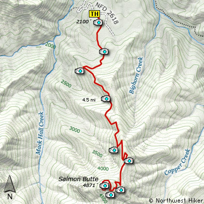
Map of the Salmon Butte, Salmon Huckelberry Wilderness Hike
|
Length: 12 miles round trip
Elevation Change: 3200' gain
Season: Late Spring thru Fall
Difficulty: Difficult
Permit: NW Forest Pass Required
Features:
NEW!
Click for PDF Topo Map of this Hike
Note: Due to the road wash-out a few years
back, the hike is 3 miles longer and gains an additiona 430 feet in elevation.
This is one of those delightful hikes with little popularity. It climbs pretty steeply,
so I call it Difficult, but it is a great hike. Located in the heart of the Salmon-Huckleberry
Wilderness, Salmon Butte offers outstanding views and lots of spring and summer flowers.
The trail head parking area is a simple little pullout on Forest Road #2618. The trail head
is not well marked. You used to drive up a little dirt road to the trail head, but they
placed a berm there, so now you park on the forest road and hike in the additional few
hundred feet. The locals have not been kind to this area, but don't let that discourage
you. This hike is worth it.
Just as you begin the hike, you will come to the forest service sign in booth. Then
you're on your way. The trail wanders through an old forest with large cedars and
hemlocks. As you climb the trail is often lined with the ever present Rhododendrons.
In season they are beautiful and add much to the enjoyment of this hike. From time
to time there are breaks in the dense forest and you get opportunities to enjoy the
vistas.
The steep climb is broken up by several switchbacks which make the grade tolerable.
The greenery that lines that trail makes it look surreal at times. About 3.5 miles
into the climb you will change over to the eastern side of the ridge. Here you
will be treated to great vistas of not only Mt Hood, but Devil's Peak, and the
Salmon River valley below you. At about 4 miles the trail gets fairly steep for
just a short distance and you come to the junction of the old service road that
approaches from the south. Bear to the right and follow this road, turned trail,
around the north side of the butte to the west side where you approach the top.
The reward is here on top. Views abound and the reward is great. Enjoy.

Mt. Hood as seen from the summit of Salmon Butte
|
How to get there:
NEW!
Click for PDF Directions Map of this Hike
Follow US Highway 26 about 17 miles east
of Sandy. Turn south on the Salmon River
Road #2618, following it for about 5
miles you will come to a fine bridge that
crosses over the Salmon River. In about
another half mile, you will come to the
place where the road has been washed out.
You will have to park here and begin you
hike. This feature adds another 3 miles
to the hike and another 430 feet of elevation
gain, making the hike a bit more difficult
than before.
|
|
|
A Virtual Hike of the Mount Hood National Forest


|
|


