

|
THE FOLLOWING MAP IS NOT TO BE USED FOR NAVIGATIONAL PURPOSES.
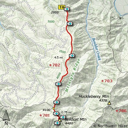
Map of the McIntyre Ridge, Wildcat Mountain Hike
|
Length: 10.5 miles round trip
Elevation Change: 1530' gain
Season: Late Spring thru Fall
Difficulty: Challenging
Permit: NW Forest Pass Required
Features:
NEW!
Click for PDF Topo Map of this Hike
Here is another example of a really super hike that doesn't get good press. Again, the
locals have not been good to this hiking area, but you should not let this keep you from
enjoying of the Salmon Huckleberry's best hikes.
The parking area at the end of Wildcat Creek Road leaves a lot to be desired. Lots of
munition casings and broken glass. So, there is safety in numbers. You might not
want to leave your vehicle overnight. I've never had a problem on day hikes. After
you park, you will walk up a 4 wheeler road for just a bit before the trail actually
begins. It is as you enter the forested area to the southeast of where you park that
the hike truly begins.
Almost immediately you come to the sign announcing your entrance into the Salmon Huckleberry
Wilderness. The trail climbs a bit then drops a bit as you hike through Rhododendron lined
paths. For the first half mile you have breaks in the timber where you can see out to
views of Mt Hood. Then the next mile and a half is pretty much in dense forest, and the
trail climbs rather steeply for a portion of this section. About two miles into the hike
you come to the first significant viewpoint. This makes a fine destination in itself, and
the photo opts are excellent.
The trail then re-enters the dense forest and remains that way as you climb one of the
steepest parts of the hike. In about three quarters of a mile you'll come out into a
beargrass ladened meadow with an obscure path to your left that used to take you to a
fine viewpoint, but it has pretty much been overgrown now.
The trail now looses a bit of elevation and you continue to hike mostly in forested
surroundings. Another mile later you will come out into the open and
enjoy some of the best views of the hike. You'll climb a little bit to a summit that
affords you spectacular views. The floral displays are great in season.
The trail drops off this little summit and passes a newly install bench dedicated to
an individual who loved hiking. The view from the bench is as good as it gets. The
trail continues down a bit, then gently climbs back into the forest. After you climb
over the shoulder of the next mound, you descend a bit then walk through another
Rhododendron line pathway. The trail does climb a bit before you intersect Trail #781,
which you will follow to your left.
You will come to another sign announcing your entrance into the Wilderness. This
is for the hikers who begin their hike on Trail #781. Now the trail becomes steeper.
You are literally climbing Wildcat Mountain. The trail climbs along the northern
edge of the mountain, so you are afforded outstanding views from time to time. You
will be able to see Mt St Helens, Mt Rainier, Mt Adams, and of course Mt Hood. At
about a half mile, you'll need to look for the cutoff trail that takes you to the
actual summit of Wildcat Mtn. This is a very short steep climb and then you are
on top. The summit used to have a fire lookout. The trees have now grown quite tall
and to get great views you need to walk through the dense brush to the south of the
summit for views of Mt Jefferson and the headwaters of Eagle Creek. From the summit
you'll need to walk northeast through the dense brush to enjoy spectacular views of
the mountains to the north, and of course Mt Hood.

Mt. Hood as seen from the Wilcat Mountain trail
|
How to get there:
NEW!
Click for PDF Directions Map of this Hike
Follow US Highway 26 east of Sandy
for about 10.5 miles. Turn right
on Wildcat Creek Road, just
past the gas station next to the
Shamrock Motel. Stay on the graveled
road for about 1.5 miles, when you
need to bear left at a "Y" in the
road. Bear left again at the next
"Y", but bear right at the final
junction. The road ends in a wide
parking area. It is prone to
vandalism.
|
|
|
A Virtual Hike of the Mount Hood National Forest


|
|


