Length: 4.2 mi RT
Elevation Change: 475' gain
Season: Summer thru Fall
Difficulty: Moderate
Permit: NW Forest Pass Not Required
Features:
NEW!
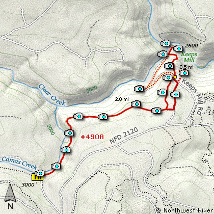
Click for PDF Topo Map of this Hike
I included this hike because of its proximity to the newly created Lower White
River Wilderness Area. The trail runs from Camas Prairie to the Keeps Mill Campground
located on the bank of the White Water River.
In season this hike can offer wonderful wildflower displays and in good weather modest
views of Mt. Hood. I began the hike where the trail crosses FR240 about a half mile before
Camas Prairie. There isn't any actual parking here, so just find a place off the paved
road and walk back to the trailhead itself.
The trail is getting a bit overgrown but is very easy to follow. It has changed location over
the years, but still provides a great hike as you descend along Clear Creek to the White River.
A couple of miles into the hike, the trail takes you up and along a cliff area where you get your
best views of Clear Creek. Shortly after this view area, the trail intersects an old road which
you can take to continue your hike, or if you look carefully, you will see the actual trail continue
on through the forest. Most of this hike is in some sort of forested area; sometimes newer growth,
sometimes older growth, but never Old Growth.
At about two and a half miles the trail crosses the road that takes campers to the Keeps Mill
Campground. If you look to your right, you will see a bit of a rocky outcropping, and this is
worth the diversion. Just walk up the road to your right a hundred feet or so, then bear left
and walk out onto the prominence. Here you get great views of the White River Valley.
Return to your trail the way you came.
I recommend following the actual trail down into the valley through a number of switchbacks. You
will hike along a rocky exposed area for a bit, but then back into the dense forest. Eventually,
the trail comes back out on the same road you crossed earlier before you began the drop into the
valley. Just bear right on this road and follow it to the campground. When I was there the
Keeps Mill Campground was in good condition. The restroom was fine and the tables all had small
piles of firewood stacked near them.
If you walk through the campground, following the White River downstream, you will find a users
trail that takes you to remnants of the old Keeps Mill. Also, in late summer when the river is low,
people actually drive their vehicles across the river and follow an old road on the north side
just to explore or to reach Forest Road 48. When you decide to return to your vehicle, I'd suggest
walking back up the access road until you come to that place where you crossed the road on the
way down. This makes a small loop out of the hike and gives you great views of Clear Creek below.

White River Canyon as seen from the Keeps Mill Trail
|