

|
THE FOLLOWING MAP IS NOT TO BE USED FOR NAVIGATIONAL PURPOSES.
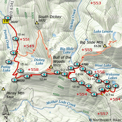
Map of the Welcome Lakes Hike
|
Length: 11.8 mi RT
Elevation Change: 2675' gain
Season: Summer thru Fall
Difficulty: Difficult
Permit: NW Forest Pass Not Required
Features:
NEW!
Click for PDF Topo Map of this Hike
The trailhead begins at Forest Road #6341. This is the same trailhead you would use to
hike to Bull of the Woods Mountain or to
Big Slide Mountain or just to Pansy Lake. You begin a gentle climb through large standing
timber, no doubt old growth. The trail crosses several small streams and is often lined
with the wonderful Rhododendron. At about a mile you come to the junction to Trail #549.
To reach Bull of the Woods Mountain you would bear left on Trail #549, but for this hike
continue on straight ahead toward Pansy Lake.
At about a mile and a half you will come to a small trail breaking off to the right which
takes you to the Pansy Lake shoreline. As long as you are here, it would be a shame to
not take a few moments to drop down to the lake to enjoy its unique beauty. Settled in a
small cirque, the lake is surrounded by beautiful forested hills all around. After this
brief detour, head back to Trail #551 and continue south, climbing your way through a series
of switchbacks to the junction with Trail #558. As you climb toward the saddle, there
will be a couple of opportunities to view Pansy Lake below. You may have to walk off the
trail just a few feet to catch you best views, but it is truly worth it.
At the saddle junction, bear left or east onto Trail #558 and follow this trail to the next
junction. This part of the hike offers some spectacular views of Mt. Jefferson to the southeast,
but it will get incredibly better as you near Big Slide Mountain itself. Also, along this part
of the trail I have found the beautiful Blue Flax Wildflower and the fiery red Scarlet Gila or
Rocket Flower. In season there are a lot of beautiful wildflowers along this entire hike.
In a couple of miles you will come to the junction of Trail #554. Bearing a sharp left on
this trail will take you to the summit of Bull of the Woods Mountain, so for this hike, you
want to continue on to the right, or east. You will follow Trail #554 only a short distance
as you climb your way to the next junction of Trail #555. This is the trail that will take you
to Big Slide Mountain, but it also will take you to the trail to Welcome Lakes,
so bear left and head downhill. You will drop rather steeply into
a saddle that rests between the trail to Big Slide Lake, Big Slide Mountain, and Welcome
Lakes.
When you reach the junction to Trail #556, bear right and follow this trail to Welcome Lake.
The trail is kinda level for entire distance to the Upper Welcome Lake. I mean, there is some
up and down, but nothing compared to the climb out of here on your return to the trailhead. As
you hike along this section of the trail, you will be in and out of the forested areas, but there
is enough out to give you good views of the surrounding hills and valleys. Only about a half
mile into this section of the trail you will come to an open area with an exposed rocky viewpoint
to your left. Leave the trail and walk over to the edge of this and you can catch a glimpse of
West Welcome Lake. In another mile or so you will come to Upper Welcome Lake, which is a real
pretty little lake surrounded by Rhododendrons. In season this really adds to the beauty of this
place. There are also a number of acceptable camp areas not far from the lake.
As you walk along the eastern shore of Upper Welcome Lake you will come to the outlet stream. When
you cross over you will come to a major junction (and campsite). From here you can follow Trail #554
downhill to the Lower Welcome Lake. This is the largest of the Welcome Lakes and has a difficult
shore to reach. After your visit to the lower lake, you will return on the same trail to this major
junction. Continue straight ahead on Trail #554 as it climbs steeply to the ridge that you were on
earlier before descending on Trail #555. After several switchbacks you will reach the ridge line, and
again, bear right and stay on Trail #554. You are looping around and will come again to the junction
of Trail #555, the one you took downhill to the junction with Trail #556.
This time you continue straight ahead for a short distance on Trail #554 until to come to the junction
you were at several miles ago... Trail #558. At this point you have two options. You can continue on
straight ahead and follow Trail #554 up to the summit of Bull of the Woods Mountain and eventually
connect with Trail #549 that will take you back down into the valley and meet up with Trail #551 which
will take you back to the trailhead. OR, you can simply return to the trailhead on the same route you
took to get here in the first place.

Upper Welcome Lake
|
How to get there:
NEW!
Click for PDF Directions Map of this Hike
Follow Hwy 224 southeast of Estacada approximately 25 miles until it becomes
Forest Road 46 just after the Ripplebrook Ranger Station and the junction with
Forest Road 57. Continue south for about another 3.7 miles to the junction
with Forest Road 63. Bear right onto FR 63 and cross over the Clackamas River.
The road now follows the Collawash River for approximately 3.5 miles until you
come to the junction with Forest Road 70.
Continue on FR 63 for approximately 2.2 miles and on your right Forest Road 6340
will veer off and uphill. Follow FR 6340 for about 7.8 miles to the junction with
Forest Road 6341. Bear right onto FR 6341, which ironically is paved. Continue
on for about another 3.6 miles and as the road crosses a creek, veering to the right,
you will see the trailhead sign and parking on the right side of the road.
This is the same trailhead for Pansy Lake, Bull of the Woods Mountain, Big Slide Mountain,
Lake Lenore, and Welcome Lakes.
|
|
|
A Virtual Hike of the Mount Hood National Forest


|
|


