

|
THE FOLLOWING MAP IS NOT TO BE USED FOR NAVIGATIONAL PURPOSES.
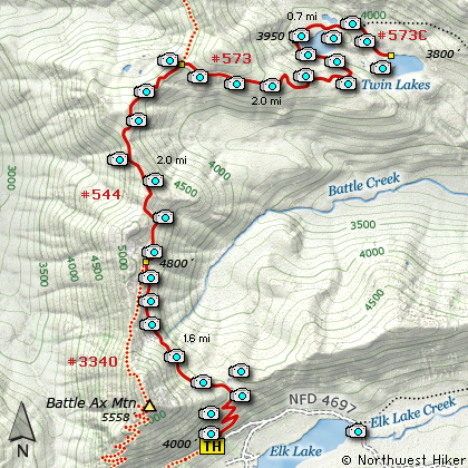
Map of the Tin Lakes via Elk Lake TH Hike
|
Length: 11.8 mi RT
Elevation Change: 2050' gain
Season: Summer thru Fall
Difficulty: Difficult
Permit: NW Forest Pass Required
Features:
NEW!
Click for PDF Topo Map of this Hike
There are many ways to reach the Twin Lakes in the Bull Mtn Wilderness. This narrative
will take you there from the road to the Battle Ax Mountain trailhead. The trail to Twin
Lakes doesn't have a good parking area, so you may need to drive just a bit further to the trailhead
to Battle Ax Mountain, and then walk back down the road to catch this trail.
Trail #544 climbs steeply right out of the gate and gains over 600 feet in the first mile.
Then it reaches a plateau which presents a small pond on your right for your enjoyment as you walk by.
The trail then climbs gently for the next couple miles as it wanders in and out of forested areas,
past small ponds, and through rocky exposed areas. The trail will come to the junction of Trail #3369,
which is the trail that takes you up and over Battle Ax Mountain. Actually, I use these two trails
to complete a loop of Battle Ax when I climb it.
As you continue on the trail will continue to climb until it crosses over the ridge line that it has
been following most of the hike. As you cross over the west side of the ridge, you can catch views
to the west, looking down Battle Ax Canyon and over to Whetstone Mountain to the northwest. The
trail doesn't stay on the west side long, and crosses back over to the east side, giving you some
great views of the surrounding mountains and especially Mt. Jefferson to the southeast. At about
4.5 miles, you will come to another major junction. This is the same junction you would come to
if you chose to hike to Twin Lakes from the Whetstone Mountain trailhead. Actually, the trail you
are on, Trail #544, is the trail that goes all the way over to Bagby Hot springs.
At this junction, bear right (east) and follow Trail #573 to Twin Lakes. The trail runs along
the southern exposure of the ridge it is on, and gently works its way downhill. There are times
when you will have excellent views of Battle Ax Mountain to the southwest of you and Mt. Jefferson
to the southeast of you. In season the wildflowers are exceptional and add great beauty to the hike.
I have also hiked here in the late summer, and the flowers were no longer plentiful, but the fall
colors were already presenting themselves, which is a real treat if you can't get here until fall.
In a mile or so the trail will make a sweeping turn to the left (west) and begin its descent to
the first of the Twin Lakes. The nearer you get to the lake, the more frequently you will see
glimpses of the lake through the trees. The trail comes out right at the extreme west end of the
lake and if you are quiet and careful, there is a good chance you will see wildlife.... even maybe
an otter. The trail then makes its way around the lake on the north side. It gains a little elevation
here, which then in turn gives you great views looking down on the very colorful lake.
If you choose to hike over to the second of the Twin Lakes, you will find it a lot more challenging.
They have not kept the trail up and it is difficult to follow sometimes. Recently there was a forest
fire here and the trees have fallen over the trail and when I hiked it in the fall of 2009, it was
quite a mess. Nevertheless, I was able to reach the lower lake shore. The fire did remove some of
the original beauty. Yet, I thought the struggle to get there was worth it, and I hope you do too.
Of course there are a number of places to camp along both lakes, and whether you do or not, you can
return to your vehicle the same way you came. Also, remember, you could return via Battle Ax Mountain.
Just follow Trail #3369 when you come to it, and it will take you over the top and back down to your
vehicle. Enjoy!

Mt. Beachie and Battle Ax Mountain
rise above Elk Lake
|
How to get there:
NEW!
Click for PDF Directions Map of this Hike
To reach Elk Lake and the trailheads for Battle Ax Mountain and Twin Lakes,
is quite an adventure. Regardless of where you begin your journey, you will
have to end up on Forest Road 46, which is the forest service's version of
Hwy 224, that goes between Estacada and Detroit Lake.
About 65.4 miles south of Estacada or 4.5 miles north of Detroit, turn on
Forest Road 4696. Go northeast for about .7 miles, and just after you cross
over a creek, bear left onto Forest Road 4697. Follow FR 4697 the 7 miles to
the Campground turnoff at the west end of Elk Lake. Continue past the campground
about a quarter mile and the road ends due to a washout. In that quarter mile
you will pass the trail that leads to Twin Lakes and other points north. The
trail to Battle Ax Mountain continues along this road beyond the point of closure.
|
|
|
A Virtual Hike of the Mount Hood National Forest


|
|


