

|
THE FOLLOWING MAP IS NOT TO BE USED FOR NAVIGATIONAL PURPOSES.
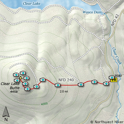
Map of the Clear Lake Butte Hike
|
Length: 4 mi RT
Elevation Change: 1100' gain
Season: Summer thru Fall on foot
Difficulty: Challenging
Permit: NW Forest Pass Required
Features:
NEW!
Click for PDF Topo Map of this Hike
This is a four mile round trip hike on pavement almost the entire way. I include it on this
CD because it takes you to another one of the five fire lookout towers whose structures
are still in tack within the Mt. Hood National Forest. Three of these can be rented,
and the Clear Lake Butte tower is one of them.
You can hike or in the winter season ski or snowmobile to the tower. But only those who
have reservations will have a key for entry. Nevertheless, the tower is fun to visit
and you can climb almost to the top without a key. Key or no key, the only parking
available is at the gate that crosses Forest Road 240. Be sure that you do not block
the gate in any way.
In season there are a variety of beautiful wildflowers along the
road which add to the joy of this delightful little hike.
The road travels in and out of rather dense forest with very few views.
But after about two miles, you approach the summit of Clear Lake Butte and
there are more and more opportunities to see in all directions.
There is a nice clean restroom facility at the base of the tower, and a picnic
area. You actually need to climb the tower to get great views of the surrounding
lakes and mountains. Mt. Hood to the northwest is the most prominent feature, but
Mt. Jefferson to the southeast and Timothy Lake to the south are clearly visible.
The original lookout was built by the Forest Service in 1932, and was on a 100 foot tower.
In 1962 it was replaced with the present lookout. The lookout is an "R-6 Flat Top" style
cabin, a design introduced in 1953 as the last generation of fire lookouts in the region.
The design, which includes a flat, tarred roof, originated in the Pacific Northwest and
was designed to alleviate costs and hazards associated with re shingling the roofs typical
of earlier style lookouts. Window shutters, a feature of earlier lookouts, were eliminated
in this new design, and an extra foot of dimension added over previous lookouts (15 x 15 ft.).
These newer lookouts used plywood as a construction element, another new feature.
This tower can be rented.
Click Here to view more information on this and other fire lookout towers.

View of Mt. Hood from the stairs
up Clear Lake Butte Lookout
|
How to get there:
NEW!
Click for PDF Directions Map of this Hike
In summer, if you plan to hike to the tower, take US Hwy 26 past
Government Camp, and toward Madras and Bend until you come to the
Skyline Road, which is Forest Road 42. Follow this road south as
if you were going to Timothy Lake or Olallie Lake. At about one
and a half miles you will come to Spur Road 240 on your right.
Park on the side of the road by the gate, but do not in any way
obstruct the gate. From here you can hike to the tower.
In the winter, however, access begins at the Skyline Sno-Park which is
just off US Hwy 26 on the Skyline Road. Visitors park at the Sno-Park and ski,
snowshoe or snowmobile into the facility. From the parking area, proceed on FR42
to the 240 spur road, approximately 1.5 miles. Then follow the spur road
to the tower. This is a good ski for moderate skiers and will take three and a half to four hours.
|
|
|
A Virtual Hike of the Mount Hood National Forest


|
|


