Hike 97
The Mt. Hood National Forest
Little Zig Zag Falls Hike
Search Northern Hikes Mt Hood Hikes Eastside Hikes Central Hikes Southern Hikes
Home Page
Main Map


Click to view product details

THE FOLLOWING MAP IS NOT TO BE USED FOR NAVIGATIONAL PURPOSES.
Map of the Little Zigzag Falls Hike

Length: 1.5 mi RT
Elevation Change: 50' gain
Season: Late Spring thru Fall
Difficulty:    Easy
Permit: NW Forest Pass Required

Features:

NEW!
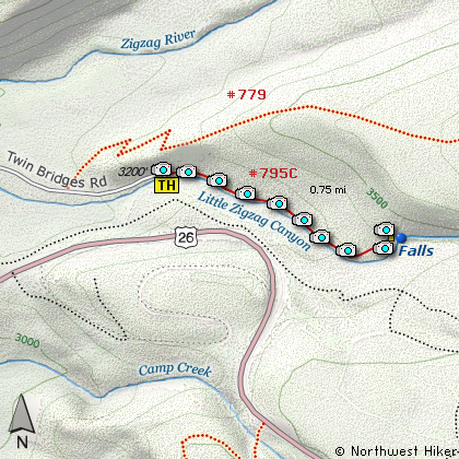
 Click for PDF Topo Map of this Hike 

Now here is a popular little hike for the whole family. The nearly level trail is less than a half mile long and winds along the banks of the Zig Zag River. In season there is an abundance of wildflowers to enjoy along the way. Actually, if the access road isn't snowed in, you can hike this little gem year around.

Remember to always be attentive to your young children if you bring them to this wonderful place. The water is cold and swift, yet very delightful on a hot summer day.


Trail to Little Zig Zag Falls
How to get there:

NEW!
 Click for PDF Directions Map of this Hike 

Take U.S. 26 to 4.3 mi. east of Rhododendron and turn northwards onto Rd. 2639 (Kiwanis Camp Road). Continue to the end of this road (2.2 mi.) and a large parking area. The trailhead is at the north end of the parking area.


Hike Difficulty Calculator

Calorie Burn Calculator

The 10 Essentials
Bear Encounters

Cougar Encounters

River Crossing Safety
A Virtual Hike of the Mount Hood National Forest


Click to View Instructions