

|
THE FOLLOWING MAP IS NOT TO BE USED FOR NAVIGATIONAL PURPOSES.
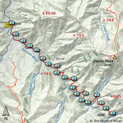
Map of the Salmon River Hike
|
Length: 12 mi RT
Elevation Change: 1200' gain
Season: Late Spring thru Fall
Difficulty: Challenging
Permit: NW Forest Pass Required
Features:
NEW!
Click for PDF Topo Map of this Hike
There are a couple of trails along the Salmon River just south of Welches, OR.
This hike begins at the large bridge that crosses the Salmon River and where
Forest Road 2618 turns into gravel. The trailhead and parking area is on the
east side of the road, just before the bridge.
Trail #742 follows the Salmon River at varying distances from its banks,
and varying elevations above the river, all the way to Forest Road 309,
which connects to Forest Road 2656 from Trillium Lake.
I will present only the first 6 miles of this trail to the junction with Trail #665,
which leads to Kinzel Lake and the trail to Devils Peak.
There are probably two great reasons to hike this trail, if you do not plan to stay at one
of the many campsites overnight. One is the Salmon River and it's awesome beauty. The other
is the ancient forest that you will get to enjoy from time to time. It is obvious to any
visitor that there has been a fire in the not too distant past, which eliminated a lot of
the large old trees. Nevertheless, the forest is beautiful and in season there is an
abundance of gorgeous wildflowers.
During the first couple miles of the hike, the trail keeps fairly close to the river. But
after you enter the Salmon-Huckleberry Wilderness, the trail begins to climb up and away from
the river. One of the features that makes this a fun hike are the occasional rock outcroppings
where you can catch some great views of the Salmon River Canyon and the surrounding hills.
Again, the time of year that you choose to hike this trail will determine how prolific the
wildflower displays will be. One reason to hike this in the late spring and early summer is
because the river is still flowing vigorously and the wildflowers are abundant.
Also, Click Here for useful suggestions on river crossings.

Salmon River Canyon from the trail
|
How to get there:
NEW!
Click for PDF Directions Map of this Hike
To reach the trailhead for the Salmon River hike, just head east from the
Portland/Gresham area on US 26 toward Mt. Hood. Pass through Sandy and
continue on to Welches. There is a single stoplight in Welches, and after
you pass through this light and just after you pass the fire station on your
right, keep an eye open for the Salmon River Road, which will also be on your right.
Turn right (south) onto the Salmon River Road (Forest Rd 2618) and travel about 5 miles to a
large bridge where this paved road crosses the Salmon River. Just before the
bridge and on your left is the trailhead for the Middle and Upper Salmon River
Trail. Park here.
|
|
|
A Virtual Hike of the Mount Hood National Forest


|
|


