Length: 10 mile loop
Elevation Change: 2000' cumulative elevation gain
Season: Summer thru Fall
Difficulty: Difficult
Permit: NWF Pass Not Required
Features:
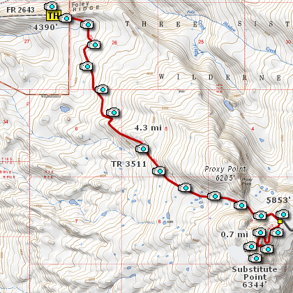
This hike begins on what is called the Foley Ridge Trail #3511.
The trail is a main link to the Pacific Crest Trail from a west
side approach to The Husband and/or the Three Sisters themselves.
The hike to Subsitute Point is almost entirely within a forested
area with very little views along the way. In season, however, this
can be a very enjoyable wildflower hike. Because of the elevations
along this trail, you might even find snow in the shady areas as late
as August. However, it should not be a problem for staying on trail.
The trail meanders to the southeast as it gently climbs toward
Subsitute Point. The overall elevation gain is over 2000 feet.
Also, in July you are very likely to encounter a serious number
of mosquitos and even the black flies.
At about 4.3 miles you will come to a junction where Trail #3511
continues on to the east toward the Pacific Crest Trail. You will
want to bear right and begin the final climb to the summit of
Substitute Point. Even here the trail is mostly within the forest,
but soon you will break out into ever increasing views of the
mountain to the east.
The final section of the trail, just before the summit, is very
rocky and steep, but not dangerous. Rather is it kind of
spectacular and you rise over the ridge to the fantastic views
in all directions.
This hike is not for faint hearted. It is long.
Take plenty of water, and rest often.
|