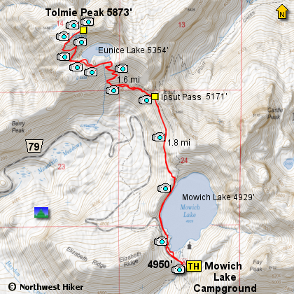
Length: 6.8 mile RT
Elevation Change: 1100' cumulative elevation gain
Season: Summer thru Fall
Difficulty: Moderate
Permit: Park Entrance Fee
Features:
The trailhead for this hike is located west
of the campground near Mowich Lake.
Tolmie Peak Lookout hike ranks amoung the top
ten best values in scenery for hike effort exerted
within the Mount Rainier National Park
in this writer's opinion. The seven mile round
trip event offers two beautiful lakes and a summit
experience with a breath taking view.
If swimming in mountain lakes is your thing, then
you will want to check out Eunice Lake as it looks
to be one of the best for swimming with sandy shores
and easy
access.
An added benefit to this hike is Mowich Campground
at the trailhead. The campground requires no
reservations, but the number of campsites is limited.
This also means that there are restrooms that are
well maintained. The trailhead often has park
rangers nearby because they have a small headquarters
near Mowich Lake. The only downside to the campground
is the lack of privacy from surrounding camper. This
campsite is more functional than it is scenic. It is
often used for support crews that assist others who
are hiking the entire Wonderland Trail around Mount
Rainier.
For the best experience, you may wish to start your
hike to Tolmie Peak early in the day as there is a well
know tendency for Mount Rainier to cloud up around noon
time. The mountain is often best for viewing early or
late in day day generally speaking.
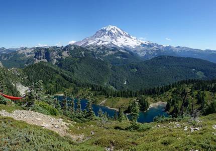
View of Mount Rainier
from Tolmie Peak Lookout
|