Length: 4 miles round trip
Elevation Change: 800' cummulative elevation gain
Season: Summer thru Fall
Difficulty: Moderate
Permit: No Forest Pass Required
Features:
NEW!
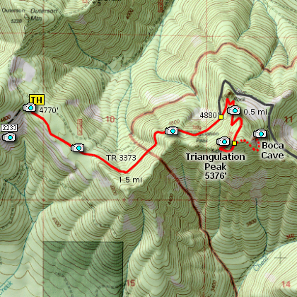
Click for PDF Topo Map of this Hike
Now here is a real gem tucked away on
the very edge of the Jefferson Wilderness
Area. This is a short hike and barely
ranks as moderate. The hike to
Triangulation Peak is family and pet
friendly.
From the trailhead it is about a
mile and a half to the junction
which takes you off of Trail 3373
and onto Trail 3374. It is about
another half mile to the summit.
In early July this hike is adorned
with incredible floral displays. As
soon as you leave the parking area,
the trail descends for about a half
mile through fairly dense forest.
Then the trail begins to climb gently
for another mile to an obvious junction.
At this junction, bear to the right,
and head uphill for another half mile
to the top of Triangulation Peak. The
views are breath-taking and so worth
the effort.
If you want to venture to Boca Cave,
well, that's another matter. This is
not an established trail and it is
not family or pet friendly.
A couple hundred feet back down the
trail from the summit of Triangulation
Peak a user's trail bears off to the
right, or east, and will take you to
Boca Cave. The user's trail descends
steeply through dense forest to the
bottom of a cliff into which you will
find Boca Cave.
Northwest Hiker does NOT recommend
the hike to Boca Cave for anyone
who is not in excellent physical
condition and has a vast amount of
hiking experience.
Enjoy!
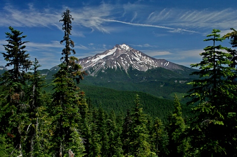
Mt. Jefferson from Triangulation Peak
|