Length: 7 mi RT
Elevation Change: 50' cumulative elevation gain
Season: Year round
Difficulty: Easy
Permit: No permit required
Features:
There are two trailheads or access points to this
trail. You can begin at the parking area at the north
end off NE Goodwin Road. Or you can start at the
south end off NE Lake Road. Either way is fine.
I hiked the trail from the north to the south and back.
All the phones are taken while hiking south.
This is an excellent hike in many ways. It is very level,
therefore hikers of all ages can enjoy it. One does not
have to hike the entire trail. There are mileage posts
every 1/4 mile, so you always know how far you have come
and how far it is to the end.
The trail is hemmed in on one side by Lacamas Creek or
Lacamas Lake and on the other side by private homes or
a golf course.
I was very impressed at the effort that has been put in
to creating this excellent trail. Even though it is located
in the town of Camas, most of the hike leaves you feeling as
if you were out in the wilds.
There is a section of the trail where you are in direct
view of the nice homes along the trail. But most of the
trail allows you to feel like you are not in the city.
I highly recommend this hike for those who like a good
exercise hike that is very close to the metro area, yet
has a feel of being in a more rural environment. I noticed
a lot of joggers and runners on the trail the day I hiked it.

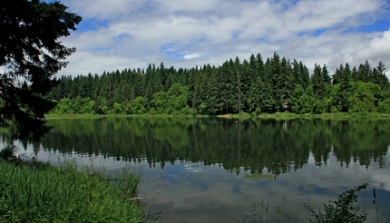
Looking across Lacamas Lake from the shoreline trail
|